Showing posts with label Chennai. Show all posts

Sunday, March 29, 2015

Tornado in outskirts of Chennai on September 2013


A tornado is a violently rotating column of air that is in contact with both the surface of the earth and a cumulonimbus cloud or, in rare cases, the base of a cumulus cloud. They are often referred to as twisters. Tornadoes come in many shapes and sizes, but they are typically in the form of a visible condensation funnel, whose narrow end touches the earth and is often encircled by a cloud of debris and dust. Most tornadoes have wind speeds less than 180 km/h. Most extreme tornadoes can attain wind speeds of more than 480 km/h. The scale of intensity for Tornado is given below.


Tornado in India

The areas of  occurrence of tornadoes in India are given in fig below. About 72% of the reported tornadoes in India have occurred in northeast India and Bangladesh.


About 76% of the tornadoes in India occur during March to May, the most favored month being April (see fig below) More number of tornadoes have occurred in the afternoon and evening. 72% of tornadoes are associated with “KalBaishakhi”.


F-3 Tornado in Odisha on March, 2009

During noon of 31st March 2009, A Tornado ravaged Odisha, a high winds damaged the villages in a narrow track of about 600 metres wide upto 6 kilometers long from the origin. The intensityof the tornado increased gradually and was maximum over Baghabuda. The tornado also passed over the water bodies like ponds in the villages, as fishes weighing 1-2 kg were found scattered. The photo of the the Tornado was put up in Odisha Diary.


It was an F-3 category Tornado, you can see the funnel upto the surface. It caused huge devastation and loss of life in Odisha. Lets now see Chennai's Tornado in 2013.

Possible F-0 Tornado in outskirts of Chennai September, 2013

There is some disagreement over the definition of funnel cloud and condensation funnel. According to the Glossary of Meteorology, a funnel cloud is any rotating cloud pendant from a cumulus or cumulonimbus, and thus most tornadoes are included under this definition. Among many meteorologists, the funnel cloud term is strictly defined as a rotating cloud which is not associated with strong winds at the surface, and condensation funnel is a broad term for any rotating cloud below a cumuliform cloud.

Chennai's Twister

So what was is it in Uthandi in outskirts of Chennai was it only a funnel cloud or did it have surface winds from the funnel cloud. The day was September 12, 2013, and the time was 4.30 pm. Robert Gagarin (58) of Uthandi happened to be on the rooftop of his house in time to catch a glimpse of a tornado in the distance.
“The sky turned pitch dark and I saw a circular cone shaped cloud formation for about 15 minutes. I clicked some pictures and also a video with my smart phone,” says an excited Robert according to Deccan Chronicle.

IMD Chennai's View

Met officials confirmed that Robert Gagarin had indeed seen a tornado, the first one reported in Chennai. “Our officials, who were on their way to Puducherry too experienced some effects of this phenomenon but we confirmed it only after seeing the picture” Dr Y.E.A. Raj, Deputy Director General of Meteorology, Regional Meteorological Centre (RMC), Chennai, told the Deccan Chronicle.

“We were able to support the photos of tornado with the pictures recorded in the DWR. It was possible only because of the continuous monitoring of the weather using the Doppler Weather Radar that detects rain clouds and squally winds perfectly up to 25 km” said Dr Y.E.A.Raj, Deputy Director General of Meteorology, Regional Meteorological Centre, Chennai.

According to S.B.Thampi, director, DWR, Chennai, a strong convictive cloud passed through that area on September 12, 2013. He added that he found a tornado vortex signature (TVS) on the Doppler Weather Radar on September 12th evening, which helped them to confirm the track and the location of tornadic rotation after he learnt about the uncommon phenomenon.

Dr Y.E.A, Raj too says there was a definite disturbance during the time mentioned on ECR Road. “We not only encountered intense weather, but our officials, who were travelling in a car to Puducherry  felt the vehicle being jolted to the left of the road. It may not have been an intense tornado as the funnel clouding did not extend to the ground, but  it was unmistakably a tornado,” he concludes.
    Eitherway it was one hell of event which we Chennaites may never hear till their lifetime. Cheers to Robert Gagarin who had the passion to take snap of the once in a life time event.

    Tuesday, October 30, 2012

    Recall of 1994 Severe cyclone - As Chennai fears from Cyclone Nilam

    As Chennai is facing threat from a Cyclone Nilam, i just refreshed my memory of similar threats Chennai as faced.

    Anyone has memory of 1994 Severe Cyclone that crossed Chennai) – It was the destructive cyclone to hit Chennai in last 20 years or even more.


    This cyclone i witnessed it first hand…..to me this created havoc in Chennai. 24 cm rainfall in 24hrs coupled with 120 km/hr winds…. The cyclone scared the shit out of me. I watched the high winds with power cut without sleep. Still its scary. Hope Cyclone Nilam does not make any destruction like this.

    (Click on the images to get a bigger view)


    Friday, August 10, 2012

    7th straight day Thunderstorms visits Chennai

    Rainfall in mm ending 8.30 am on 10.08.2012


    Poonamalle –39
    Guindy - 30
    Korattur - 25
    Uthukottai - 23
    Pallipattu - 20

    Chennai City (Nungambakkam) –14
    Chennai AP (Meenambakkam) – 14
    Taramani - 14
    Madhavaram – 10

    Tambaram – 10
    Tiruttani – 10
    Tiruvalangadu - 10
    Tiruvallur –9
    Kolapakkam - 9
    Tamaraipakkam –7

    Chembarabakkam - 7
    Poondi - 5
    Cholavaram - 4

    Avadi - 3

    Saturday, December 31, 2011

    Recent Wind Speed of various Cyclones in CHENNAI

    Will Very Severe Cyclone Thane beat all the above records so far it has registered 37 km/hr winds without even coming close to the coast.
    1. Cyclone Jal 47 km/hr (7/11/2010)
    2. Cyclone Thane  43 km/hr (30/12/2011)
    3. Cyclone Laila 42 km/hr (19/5/2010)
    4. Cyclone Nisha 42 km/hr (26/11/2008)
    5. Depression BOB 08 40 km/hr (28/10/2007)
    6. Depression BOB 07 45 km/hr (27/09/2007)
    7. Cyclone Ogni 50 km/hr (28/10/2006)
    Other cyclones in last 20 years when chennai witnessed 100 km/hr winds
    1. On 6th, December 1996 (Tropical Cyclone 08B) - a Cyclone which crossed Chennai produced 100 km/hr winds
    2. On 31st, October 1994 (Severe Cyclonic Storm BOB 03) - a cyclone which crossed Chennai brought 120-130 km/hr winds

    Thursday, December 29, 2011

    Cyclone Thane Update - Cyclone Thane now Very Severe Cyclone with Winds speed over 150 km/hr

    The status of Cyclone Thane
    -----------------------------------
    Date and Time of issue - 011.30 PM (28.12.2011)
    IMD Scale - Very Severe Cyclonic Storm
    Intensity – 4.4
    Pressure – 980 mmb
    Wind Speed – 75 kts (140 kmph)
    Location – 12.23 N 83.84 E
    Weakening - OFF
    Rapid Weakening - OFF
    Landfall - Around Pondicherry
    Crossing Date - 30th December Morning

    Meteosat-7 image of Cyclone Thane


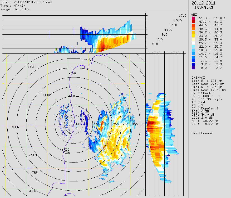
    Awesome First Glance of Cyclone in Radar

    Close up Range of Chennai Radar

    Accuweather Precipitation


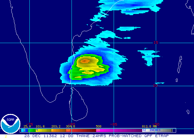
    NOAA - e-trap precipitation Forecast (Chennai to be battered)

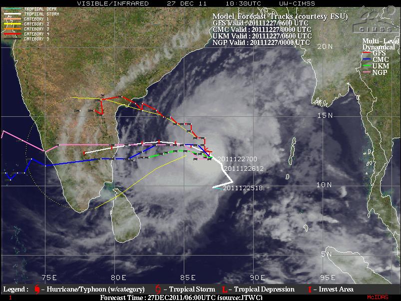
    All Major Models Forecast and Track

    JTWC Forecast and Track shows land fall near Pondy

    IMD forecast and Track shows landfall just near Chennai

    Tuesday, December 27, 2011

    Cyclone Thane update - Chennai is still the Target

    The status of Cyclone Thane as on Indian Time - 05.00 PM
    -----------------------------------
    Intensity – 3.5
    Pressure – 993 mmb
    Wind Speed – 55 kts (102 kmph)
    Location – 12.61 N 86.15 E
    Weakening - OFF
    Rapid Weakening - OFF
    Landfall - Around Chennai
    Crossing Date - 30th December Morning

    All Models Track

    JTWC Forecast and Track

    BBC Forecast


    IMD Forecast and Track

    IMD Wind Forecast

    Monday, December 26, 2011

    Chennai under Threat - Cyclone Thane, a Category 1 Storm as per ADT


    Wow what a speedy intensification the storm has gone through last 6 hours. It took 12 hours for the storm to intensify from T 2.0(30 kts) to T.30 (45 kts). But it took just past 6 hrs to intensify from T 3.0 (45 kts) to T 4.0 (65 kts). Some of the Salient status of the storm are as follows.


    Intensity – 4.0
    Pressure – 985 mmb
    Wind Speed – 65 kts
    Location – 11.06 N 87.76 E
    Scene Type – EYE/L

    Monday, October 17, 2011

    Recent Tamil Nadu Cyclones and its awesome radar images

    Deep Depression (October 26-29, 2005)


    Significant amounts of rainfall recorded in Tamil Nadu are

    27-10-2005
    Chennai 27, Chennai AP 21, and Red Hills 13 cm

    28-10-2005
    Tiruvallur and Poondi 27 cm, Red Hills 24 cm, Chembarambakkam 23 cm, Tamaraipakkam 22 cm, Chennai, Cholavaram, Korattur 16 cm, Chennai AP 15 cm and Tambaram 13 cm
    -------------------------------------------------------------------------

    Cyclone Baaz (November 28- December 02, 2005)


    Significant amounts of rainfall recorded in Tamil Nadu are

    03-12-2005

    Tambaram 31 cm, Chennai AP 28 cm, Thiruvallur and Chennai 23 cm, Arakonam 21 cm, Sriperumbudur 18 cm, Chengalpattu and Red hills 15 cm, Tiruttani 14 cm, Poondi 13 cm, Ponneri 11 cm
    ----------------------------------------------------------------------------

    Cyclone Fanoos (06-10 December , 2005)


    Significant amounts of rainfall recorded in Tamil Nadu are

    11-12-2005
    Ramanathapuram 35 cm, Panruti 14 cm, Senkottai 13 cm, Pamban, Kamudhi and Madhukar 12 cm, Kadaladi 11 cm and Ambasamudram 10 cm

    12-12-2005
    Ambasamudram 17 cm, Senkottai 13 cm and Paramakudi 12 cm
    -----------------------------------------------------------

    Depression (27-29 October, 2007)


    Significant amounts of rainfall recorded in Tamil Nadu are

    29.10.2007
    Chembarambakkam 18 cm, Red Hills 16 cm, Chennai and Chennai AP 14 cm, Cholavaram and Poondi 10 cm
    -----------------------------------------------------------------------

    Cyclone Nisha (25-27 November, 2008)


    Significant amounts of rainfall recorded in Tamil Nadu are

    25.11.2008
    Thiruvidalmarthu 30 cm, Rameswaram 23 cm, Orathanadu 19 cm, Mayiladuthurai 17 cm, Tirukkattupalli and Pamban 15 cm, Tiruvaiyar and Thanjavur 14 cm, Sirkali and Kollidam 13 cm, Papanasam and Ramanathapuram 12 cm, Kumbakonam and Kattumannarkoil 11 cm, Sethiyathope Anicut and Chidambaram 10 cm.

    26.11.2008
    Orathanadu and Vedaranniyam 33 cm, Parangipettai and Chidambaram 28 cm Thiruvidalmarthu and Mayiladuthurai 26 cm, Sirkali 25 cm, Kattumannarkoil 24 cm, Cuddalore 22 cm, Sethiyathope Anicut and Kollidam 21 cm, Tiruthuraipndi and Nagapattinam-20 each, -18 each, Karaikal 19 cm, Puduchhery, Adirampattinam Tiruvarur and Kodavasal 18 cm, Nannilam 17 cm, Valangiman, Kumbhakonam, and Tarangambadi 15 cm, Needamangalam and Chembarabakkam 14 cm, Rameswaram, Papansam, Pattukkottai, Mannargudi, Muthupet and Jayamkondam 13 cm, Korattur, Adiramapatnam and Srimushnam 12 cm, Chryyur, Red Hills and Chennai AP 11 cm, Thanjavur, Anna University, Poondi, Cholvaram, Marina and Chennai 10 cm

    27.11.2008
    Orathanadu 66 cm, Thanjavur 53 cm, Vedaranyam 42 cm, Adiramapattinam 33 cm, Muthupet 30 cm, Kurungulam 28, Kumbakonam 26 cm, Pattukottai 23 cm, Madukkur 21 cm, Tiruvidaimarudur 20 cm, Thiruvaiyaru 19 cm, Papanasam, Tirukkattupalli 18 cm, Chennai AP, Chennai and Chembarabakkam 14 cm, Korattur 12 cm, Nagapattinam, Red Hills, Pondicherry 11 cm, Poondi, Cholavaram, Cuddalore, Tiruchy and Tiruttani 10 cm

    28.11.2008
    Chennai AP 28 cm, Chembarabakkam 24 cm, Anna University 23 cm, Cuddalore 22 cm, Puduchhery 21 cm, Tiruvallur 20 cm, Tamaraipakkam 19 cm, Chengelpet, Ayiyalur, Tanjavur, Vellore-17 each, Pallipattu, Villupuram, Poonamallee, Muthupet, Poondi, Korattur 16 cm, Lalgudi, Chettykulam, Padallur, Red Hills, Tiruchchirapalli 15 cm, Tozhudur, Nungambakkam, perumbalur, Parangipettai, Srimushnam, Tiruvaiyaru, Cholavaram, Ponneri, Vanur, Chennai 14 cm, Tambaram, Tirukkattupalli, Utheriramerur, Kodavasal, Gingee, Kancheepuram-13 each, kollidam, Grand Anicut, Arni, Polur, Tirutani, Vandavasi, Tindivanam, Sriperumbudur-12 each, Thiruvidalmarthu, Chryyar, Samayapuram, Ulundurpet, Marina (DGP Office)-11 each, Tiruchi, Tiruvarur, Valangiman, Vembavur, Kumbhakonam, Orathanadu 10 cm
    --------------------------------------------------------------------

    Cyclone Laila (17-22 May, 2010)


    Significant amounts of rainfall recorded in Tamil Nadu are

    20-05-2010
    Ponneri 17 cm, Cholavaram 13 cm, Chennai, Anna University and Tamaraipakkam 11 each, Marina DGP Office 10 cm

    Saturday, October 1, 2011

    Final Verdict: All India SWM winner is Amgaon with 8965 mm rainfall in 4 months

    After 120 days of South West Monsoon, we finally have a winner and it is Amagaon from Karnataka. The legend Cherrapunji managed to cross 6000 mm mark. Amagaon & Hulikal were clear winners in 2011 SWM season.
    I will still continue to rank the toppers in North East Monsoon too. From Tamil Nadu, Chinna Kallar made the list with 4800 mm rainfall. Watch out for this place in NEM. It gets rains in NEM too.

    All India

    Rainfall in mm's (Min 4000 mm)
    1. Amgaon (Karnataka) - 8965
    2. Hulikal (Karnataka) - 8319
    3. Mastikatte (Karnataka) - 7561
    4. Amboli (Maharashtra) - 7449
    5. Kollur (Karnataka) - 7427
    6. Agumbe (Karnataka) - 7405
    7. Yadur (Karnataka) - 7309
    8. Mani (Karnataka) - 7154
    9. Gaganbawada (Maharashtra) - 6900
    10. Kogar (Karnataka) - 6851
    11. Gavali (Karnataka) - 6775
    12. Sangameshwar (Maharashtra) - 6698
    13. Mulshi Dam (Maharashtra) - 6471
    14. Mahabaleshwar (Maharashtra) - 6464
    15. Kerekatte (Karnataka) - 6259
    16. Cherrapunji (Meghalaya) - 6140
    17. Patagon Dam (Maharashtra) - 6027
    18. Kasari Dam (Maharashtra) - 5870
    19. Bhira (Maharashtra) - 5725
    20. Kerveshe (Karnataka) - 5696
    21. Kigga (Karnataka) - 5619
    22. Radhanagri Dam (Maharashtra) - 5421
    23. Koyna Dam (Maharashtra) - 5419
    24. Kadra (Karnataka) - 5325
    25. Lonavala Dam (Maharashtra) - 5318
    26. Siddapura (Karnataka) - 5289
    27. Gerosoppa (Karnataka) - 5206
    28. Tillari (Maharashtra) - 5066
    29. Gorkhana (Karnataka) - 5038 
    30. Mandangad (Maharashtra) - 4840
    31. Ajekar (Karnataka) - 4820
    32. Valpoi (Goa) - 4817
    33. Dapoli (Maharashtra) - 4813
    34. Chinna Kallar (Tamil Nadu) - 4800
    35. Chiplun (Maharashtra) - 4690
    36. Vaibhavwadi (Maharshtra) - 4638
    37. Rajapur (Maharashtra) - 4542
    38. Kankavli (Maharashtra) - 4534
    39. Bhagamandala (Karnataka) - 4532
    40. Tulshi Lake (Maharashtra) - 4526
    41. Sawantwadi (Maharashtra) - 4480
    42. Mhasla (Maharashtra) - 4445
    43. Karkala (Karnataka) - 4422
    44. Lanja (Maharashtra) - 4402
    45. Matheran (Maharashtra) - 4400
    46. Walwand (Maharashtra) - 4393
    47. Ratnagiri (Maharashtra) - 4369
    48. Dodamarg (Maharashtra) - 4291
    49. Quepem (Goa) - 4285
    50. Sudhgad (Maharashtra) - 4282
    51. Bhatkal (Karnataka) - 4266
    52. Radhanagri (Maharashtra) -4262
    53. Vadakara (Kerala) - 4231
    54. Malvan (Maharashtra) - 4219
    55. Tala (Mahrashtra) - 4170
    56. Kudal (Maharashtra) - 4078
    57. Honavar (Karnataka) - 4073
    58. Pawna (Maharashtra) - 4057
    59. Sanguem (Goa) - 4047
    60. Ponda (Goa)  - 4042
    61. Kottigehara (Karnataka) - 4031
    62. Udupi (Karnataka) - 4026
    63. Khed (Maharashtra) - 4002
    Places such as Tamini, Hulikal, Nilkund, Mawsynarm, Poochippara, Walakkad and Castle Rock would have also made the above 4000 mm list.

    Major Cities

    Apart from the above places, the rank of India's Major Cities (Population above 2 million) for the SWM are as follows
    Rainfall in mm SWM total
    1. Mumbai – 3155
    2. Kolkata – 1403
    3. Bhopal - 1266
    4. Surat – 1218
    5. Lucknow – 1046
    6. Indore - 982
    7. Nagpur – 911
    8. Patna - 871
    9. Pune – 803
    10. Chennai – 789
    11. Ahmedabad – 728
    12. Jaipur – 675
    13. Delhi – 622
    14. Bangalore – 540
    15. Hyderabad – 528
    For Chennai monsoon (NEM) is yet to begin, i am sure it will end second in the list behind for the year behind Mumbai.

    Region wise SWM Toppers

    With limited available data, the following are the region wise toppers (Rainfall in mm SWM total)

    North India

    1.Dharmashala (Himachal Pradesh) - 3180
    2.Dehradun (Uttranchal)- 2426
    3.Jammu (Kashmir) - 1238

    Central India

    1. Guna (Madhya Pradesh) - 1825
    2.Jabalpur (Madhya Pradesh) - 1692
    3.Raipur (Chhattisgarh) - 1562

    North East India

    1.Cherrapunji (Meghalaya) - 6140
    2.Chouldhowaghat (Assam) - 3026

    East India

    1.Buxaduar (West Bengal) - 3380
    2.Darjeeling (West Bengal) -2657
    3.Gangtok (Sikkim) - 2540

    North West India

    1.Kaprada (Gujarat) - 2811
    2.Pardi (Gujarat) - 2476
    3.Umerpada (Gujarat) - 2441
    4.Mt Abu (Rajasthan) - 2050

    West India

    1.Amboli (Maharashtra) - 7449
    2.Gaganbawada (Maharashtra) - 6900
    3.Sangameshwar (Maharashtra) - 6698
    4.Mulshi Dam (Maharashtra) - 6471
    5.Mahabaleshwar (Maharashtra) - 6464


    South India

    1.Amagaon (Karnataka) - 8965
    2.Hulikal (Karnataka) - 8319
    3.Mastikatte (Karnataka) - 7561 
    4.Agumbe (Karnataka) - 7405
    5.Kollur (Karnataka) - 7427

    Islands

    1.Maya Bundar (Anadaman) -3788
    2.Long Island (Andaman) -2579
    3.Port Blair (Andaman) -2297

    Saturday, September 17, 2011

    Chennai got battered by Bubble Thunder Storms yesterday

    People in Chennai cant forget the record rains we got in August 2011, where 120 year records were shattered by a distance. Particularly the 156 mm rainfall on 24th August, 2011 when thunderstorms formed in the evening kept on coming like a bubble till early morning.

    Yesterdays rainfall is also similar, first storms were spotted in radar in the evening and the storms kept on coming like a bubble till early morning. Chennai got 76 mm from this TS, thus crossing 800 mm for the year before the start of NE monsoon. Recently, Chennai's annual rainfall is increased from 1220 mm to 1400 mm by IMD and the last 10 year average works out 1460 mm with 2560 mm received in 2005 being the highest.

    We have received 836 mm till today morning, considering the rainfall and daily thunderstorms coming close to Chennai, we have to rethink whether Chennai really falls under rain shadow region. More studies have to initiated by IMD to study this daily phenomenon of Thunderstorms coming above and below belts of Chennai (from Pulicat to Pondicherry). The Radar at Chennai is also the best in India, because of less interference from height restrictions IMD has put in place for Construction of High Rise buildings.

    * The name bubble Thunder Storms was given by members of Kea blog

    Rainfall ending 8.30 am today in mm around Chennai

    Nungambakkam (Chennai) – 76
    Chembarampakkam – 60
    Arakkonam – 45
    Redhills – 42
    Kadambathur – 41
    Madhavaram – 34
    Ennore – 32
    Veeranam – 25
    Meenambakam (Chennai AP) - 21

    Thursday, August 25, 2011

    Records breaking Heavy rains in Chennai in August 2011

    Heavy rains lashed the city late in the evening on Wednesday and went on to mid night. The lack of usable storm water drains was felt keenly, as many places were flooded. As much as two to three feet of water was seen on most of the roads. The intensity of the rain sometimes was more than 100 mm/hr.

    Records Broken
    The all-time record for 24hrs rainfall in August till yesterday for Chennai was 100.3 mm recorded on 20.08.2008. Yesterday (25.08.2011) rainfall at Chennai was 156.2 mm.

    The all-time record for Monthly in August for Chennai is 336.3 mm recorded 117 years ago during the year 1894. Till yesterday (25.08.2011) the monthly rainfall at Chennai was 329.7 mm. Chennai needs just 6 mm more to break the 117 year record and it has 5 more days to go. I personally think the record will be broken.

    Rainfall ending 8.30 am at 25.08.2011 (Places in and around Chennai)

    Chennai (Nungabakkam) – 156 mm
    Korattur - 105
    Chembarabakkam - 60
    Kadambathur – 60
    Arakkonam – 38
    Red Hills - 27
    Poondi – 21
    Cholavaram - 21
    Chennai Airport (Meenambakkam) – 16
    Ennore – 14
    Gummidipoondi – 14
    Tamaraipakkam - 10
    Madhavaram – 7
    Poondi – 9
    Ellapuram – 8
    Katpadi – 7
    Madhavaram – 5

    Tuesday, June 7, 2011

    Rain takes Chennai by surprise. Receives 72mm in less than a hour

    — Photo: K. Pichumani.

    SURREALISTIC LOOK: A slice of the rain-soaked city on Monday.

    Heavy rain that lasted over an hour caught people unawares in many parts of the city and suburbs on Monday evening.

    The Meteorological Department in Nungambakkam registered 70.2 mm of rainfall during the 12-hour period ending 8.30 p.m. This is much mor e than the monthly average of 53.7 mm. Meenambakkam recorded 46 mm of rainfall during the same period. The sharp showers came after a sultry day as Nungambakkam and Meenambakkam recorded a maximum temperature of 38.4 degree Celsius and 38.8 degree Celsius, one degree above the average temperature this month. Several localities in and around the city, including Aminjikarai, Anna Nagar, T.Nagar, Koyambedu and Pallikaranai, experienced heavy showers accompanied by loud thunder. Some interior roads, including Arunachala Naicken Street at Chintadripet, were flooded. Besides affecting the traffic on arterial roads, many bus services were also hit.

    The scattered materials near the Metro Rail project site at Kathipara junction following rains aggravated the traffic snarl on the stretch. Traffic was thrown out of gear for a couple of hours around Guindy and Saidapet with vehicles piling up for prolonged period of time. Murky sky and heavy showers around 7 p.m. took motorists by surprise and many of them took shelter under trees and shops. V.S. Rajkumar, a resident of Nerkundram, said “I had to wait at a teashop for almost 20 minutes until the rain subsided.” Residents of southern suburbs such as Medavakkam, Perungudi, Sholinganallur and Velachery complained of power cut for almost an hour.

    Officials of the Meteorological Department said heavy downpour within an hour was caused by thunderstorm activity. However, such rainfall in June was not unusual. Last year, 53.4 mm of rain was registered in 24 hour period on June 28.

    The highest recorded rainfall in a single day was 347.9 mm on June 14, 1996. (Which was accompanied by Tropical Storm) The department forecasts that the rain or thundershower would occur in some areas of the city and the maximum temperature would be 39 degree Celsius.

    Source: Hindu

    Sunday, November 7, 2010

    Last Cyclones to cross near chennai

    Cyclone Ogni 2006

    One of the wettest cyclones in NIO basin. Chennai got heavy rains and registered 50km/hr winds.

    http://www.usno.navy.mil/NOOC/nmfc-ph/RSS/jtwc/atcr/2006atcr/NWP_IO/StormNWP_IO/io06.html


    Tropical Cyclone 08B (1996)


    This storm played cat & mouse and finally crossed Chennai on Dec 7th evening. i still remember this storm its so fresh in my mind)

    http://www.usno.navy.mil/NOOC/nmfc-ph/RSS/jtwc/atcr/1996atcr/pdf/nio/08b.pdf

    Tropical Cyclone 05A (1996)

    Not much wind speed wen it crossed near Chennai. It holds the record for longest cyclone in NIO basin.

    http://www.usno.navy.mil/NOOC/nmfc-ph/RSS/jtwc/atcr/1996atcr/pdf/nio/05a.pdf

    Severe Cyclonic Storm BOB 03 (1994) (04B JTWC Name)


    The first time i witnessed a storm fury. This storm crossed at mid night and i was just able to hear the wind sound it was terrifying. Most trees got uprooted in our colony.

    http://www.usno.navy.mil/NOOC/nmfc-ph/RSS/jtwc/atcr/1994atcr/pdf/nio/04b.pdf

    Saturday, July 31, 2010

    Chennai - After May & June its July's turn to be cooler & wetter

    Chennaiites are finding this month unusual — and they are not complaining. Not only has the monthly average temperature fallen , the days are getting good rains. The weatherman attributes this ‘monsoon flavour’ to low pressure formations and some other favourable meteorological systems. “The presence of an upper air cyclonic circulation over the west-central Bay with a southern tilt, a north-south trough over Chennai and a weak upper air system have the potential to bring scattered rainfall” said YEA Raj, deputy directorgeneral, Regional Meteorological Centre, Chennai.

    The trough has been present for many days during this month, resulting in light showers. For the common man, it just means he has to take out the umbrella or get drenched, happily. “This evening was almost like a monsoon day with intermittent drizzle. This is a pleasant surprise in the city which sees an extended summer till as late as October. Many residents said the weather was similar to that experienced in winter due to murky sky and intermittent showers through the day. Evening showers in the past few days have left some of the low-level areas, particularly in suburbs, water-logged.

    Chennai gets an average of 98 mm rain in July, this July Nungambakkam has registered 155 mm of rainfall. Unlike Coimbatore and Kanyakumari, which are in the windward side of the southwest monsoon, most areas do not benefit from good precipitation. Y. E. A. Raj, Deputy Director-General of Meteorology, Regional Meteorological Centre, said it was unusual for the city to be wet and receive such rainfall during July. Chennai normally receives more rainfall in August and September. While July 2008 and 2009 were comparatively drier, receiving 29 mm and 37 mm, the city has recorded good rains in July in the past.

    Thursday, July 1, 2010

    Chennai: One of the coolest June in decades

    July 01, 2010 - Times Of India

    If you enjoyed the weather more this June, you had good reason to feel as if spring was in the air. It was the third coolest June in 42 years with the mercury dipping below the average for 14 days in the month, said Met officials. “This June, the average fell from 37 to 35.2 degrees Celsius. In 1991, it was 34.3 degrees and 34.9 degrees in 1996,” said YEA Raj, deputy director general, regional meteorological centre. Since 2005, the monthly average has been higher. With the onset of the southwest monsoon, local thunder storm activity brought in a good amount of rainfall to the city. Met officials said the arrival of cyclone Laila and the rainfall in the wake of its withdrawal was the beginning of a good run on the weather front. The city enjoyed nine days of rainfall of varying degrees this June. Although nowhere near the record 698 mm seen in 1996, Nungambakkam registered 137 mm and Meenambakkam 130. The city’s normal is around 40 mm for June, added Raj. In 1991, the city received 264 mm in June.

    The thunderstorm activity was not restricted to the city alone, with all but three districts receiving excess rainfall. Against the normal of 42.1 mm, the state received 78.5 mm, an 87% excess. “The last month has been exceedingly good for the state. The trend is likely to continue in July as well, and we can expect more rains and cooler days,” added Raj.

    Saturday, May 15, 2010

    Will there be a cyclone?? Will it cross Chennai around 21st May 2010

    The US Centres for Environmental Prediction (NCEP), too, shows southwest Sri Lanka being hit during the week ending May 21. The NCEP has gone on to signal heavy precipitation over the Tamil Nadu coast and over the north-eastern States concurrently during May 21 to 28.

    Meanwhile, the CPC points towards the possibility of enhanced convective phase of the Madden-Julian Oscillation (MJO) wave and numerical weather forecast guidance forcing tropical storm formation for the Arabian Sea during next week. The CPC outlook also said that the active MJO phase would trigger enhanced rainfall for the eastern Indian Ocean and the maritime continent during this phase as well as the southern tip of Sri Lanka. Interestingly, it sees possible tropical storm spinning up over the southwest Bay of Bengal thereafter.

    This is exactly the scenario being envisioned by Prof Paul Roundy, a leading US-based ocean weather forecaster, to unfold around May 25.

    The European Centre for Medium-Range Weather Forecasting (ECMWF) has predicted that the South-West monsoon may hit Sri Lanka around May 20, a week before schedule.

    Source:Business Line
    Photo:-My Collections