Showing posts with label Cyclone. Show all posts

Friday, October 11, 2013

Mayabandar in Andaman gets over 700 mm in 3 days from Cyclone Phailin

Mayabandar till today morning has got unbelievable 735 mm rainfall in 3 days. The cyclone made the first land fall in Andaman islands close to Mayabandar. It has also got good rains till today evening, quantum of todays rainfall will be known tomorrow.

10.10.2013
----------------
Maya Bandar - 159 mm

09.10.2013
----------------
Maya Bandar - 336 mm

08.10.2013
----------------
Maya Bandar - 240 mm

Saturday, May 18, 2013

Maximum Surface Wind Speeds of recent Cyclones om North Indian Ocean Basin from 2005 while making landfall

Min 60 km/hr
  1. Very Severe Cyclone Nargis (2nd May, 2008) - Labutta, Burma - 190 km/hr
  2. Very Severe Cyclone Giri (22nd October, 2010) - Kyakpyu,Burma - 190 km/hr
  3. Very Severe Cyclone Mala (28th April, 2007) - Gwa,Burma - 185 km/hr
  4. Very Severe Cyclone Sidr (15th November, 2007) - Barguna, Bangladesh - 148 km/hr
  5. Very Severe Cyclone Thane (30th December, 2011) - Cuddalore, Tamil Nadu - 141 km/hr
  6. Very Severe Cyclone Phet (4th June, 2010) - Al-Sharqiya, Oman - 120 km/hr
  7. Severe Cyclone Aila (2th May, 2009) - Kalaikunda, West Bengal - 112 km/hr
  8. Super Cyclone Gonu (6th June, 2007) - Muscat, Oman - 100 km/hr
  9. Severe Cyclone Laila (20th May, 2010) - Bapatla, Anadhra Pradesh - 98 km/hr
  10. Cyclone Rashmi (26th October, 2008) - Chatgaon, Bangladesh - 93 km/hr
  11. Cyclone Mahesan (16th May, 2013) - Patuakhali, Bangladesh - 92 km/hr
  12. Cyclone Akash (14th May, 2007) - Cox‟s Bazar, Bangladesh - 83 km/hr
  13. Cyclone Nilam (31st October, 2012) - Chennai, Tamil Nadu - 75 km/hr
  14. Deep Depression (16th September, 2008) - Chandbali, Orissa - 74 km/hr
  15. Cycline Murjan (25th, October 2012) - Bossasso, Somalia - 70 km/hr
  16. Cyclone Phyan (11th November, 2009) - Pune, Maharashtra - 68 km/hr
  17. Cyclone Nisha (27th November, 2008) - Karikal, Pondicherry - 65 km/hr
  18. Deep Depression (17th June, 2011) - Kolkata, West Bengal - 65 km/hr
  19. Severe Cyclone Jal (7th COctober, 2010) - Ennore, Tamil Nadu - 61 km/hr
  20. Deep Depression (11th October, 2012) - Chittagong, Bangladesh - 60 km hr

Tuesday, October 30, 2012

Recall of 1994 Severe cyclone - As Chennai fears from Cyclone Nilam

As Chennai is facing threat from a Cyclone Nilam, i just refreshed my memory of similar threats Chennai as faced.

Anyone has memory of 1994 Severe Cyclone that crossed Chennai) – It was the destructive cyclone to hit Chennai in last 20 years or even more.


This cyclone i witnessed it first hand…..to me this created havoc in Chennai. 24 cm rainfall in 24hrs coupled with 120 km/hr winds…. The cyclone scared the shit out of me. I watched the high winds with power cut without sleep. Still its scary. Hope Cyclone Nilam does not make any destruction like this.

(Click on the images to get a bigger view)


Saturday, December 31, 2011

Recent Wind Speed of various Cyclones in CHENNAI

Will Very Severe Cyclone Thane beat all the above records so far it has registered 37 km/hr winds without even coming close to the coast.
  1. Cyclone Jal 47 km/hr (7/11/2010)
  2. Cyclone Thane  43 km/hr (30/12/2011)
  3. Cyclone Laila 42 km/hr (19/5/2010)
  4. Cyclone Nisha 42 km/hr (26/11/2008)
  5. Depression BOB 08 40 km/hr (28/10/2007)
  6. Depression BOB 07 45 km/hr (27/09/2007)
  7. Cyclone Ogni 50 km/hr (28/10/2006)
Other cyclones in last 20 years when chennai witnessed 100 km/hr winds
  1. On 6th, December 1996 (Tropical Cyclone 08B) - a Cyclone which crossed Chennai produced 100 km/hr winds
  2. On 31st, October 1994 (Severe Cyclonic Storm BOB 03) - a cyclone which crossed Chennai brought 120-130 km/hr winds

Thursday, December 29, 2011

Cyclone Thane Update - Cyclone Thane now Very Severe Cyclone with Winds speed over 150 km/hr

The status of Cyclone Thane
-----------------------------------
Date and Time of issue - 011.30 PM (28.12.2011)
IMD Scale - Very Severe Cyclonic Storm
Intensity – 4.4
Pressure – 980 mmb
Wind Speed – 75 kts (140 kmph)
Location – 12.23 N 83.84 E
Weakening - OFF
Rapid Weakening - OFF
Landfall - Around Pondicherry
Crossing Date - 30th December Morning

Meteosat-7 image of Cyclone Thane


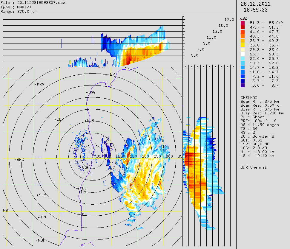
Awesome First Glance of Cyclone in Radar

Close up Range of Chennai Radar

Accuweather Precipitation


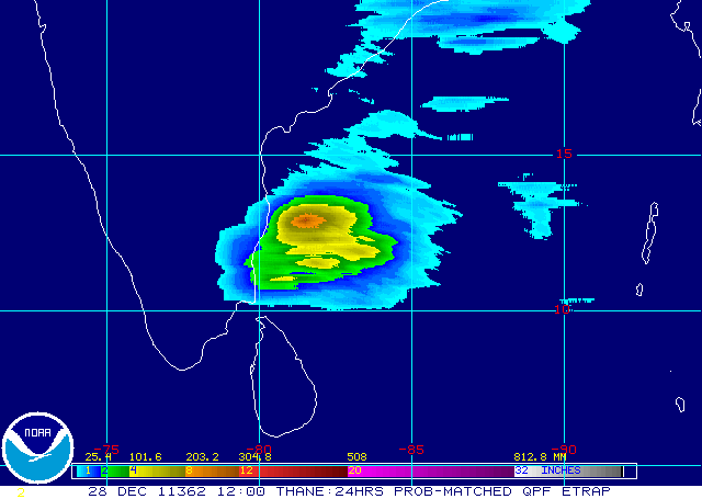
NOAA - e-trap precipitation Forecast (Chennai to be battered)

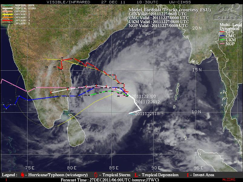
All Major Models Forecast and Track

JTWC Forecast and Track shows land fall near Pondy

IMD forecast and Track shows landfall just near Chennai

Tuesday, December 27, 2011

Cyclone Thane update - Chennai is still the Target

The status of Cyclone Thane as on Indian Time - 05.00 PM
-----------------------------------
Intensity – 3.5
Pressure – 993 mmb
Wind Speed – 55 kts (102 kmph)
Location – 12.61 N 86.15 E
Weakening - OFF
Rapid Weakening - OFF
Landfall - Around Chennai
Crossing Date - 30th December Morning

All Models Track

JTWC Forecast and Track

BBC Forecast


IMD Forecast and Track

IMD Wind Forecast

Monday, December 26, 2011

Chennai under Threat - Cyclone Thane, a Category 1 Storm as per ADT


Wow what a speedy intensification the storm has gone through last 6 hours. It took 12 hours for the storm to intensify from T 2.0(30 kts) to T.30 (45 kts). But it took just past 6 hrs to intensify from T 3.0 (45 kts) to T 4.0 (65 kts). Some of the Salient status of the storm are as follows.


Intensity – 4.0
Pressure – 985 mmb
Wind Speed – 65 kts
Location – 11.06 N 87.76 E
Scene Type – EYE/L

Sunday, December 18, 2011

Late December Cyclones: Will it happen during 2011

Many models predict cyclone to come close to Tamil Nadu coast during last week of December 2011.


I have compiled some of the cyclones which have formed in December and have crossed Tamil Nadu coast since 1950.


Almost all the cyclones have formed in the first week of December. Only one cyclone ie 1964 Rameshwaram Cyclone which crossed the Tamil Nadu coast and the 2000 Sri Lanka cyclone have formed around the Christmas period. And the 1964 cyclone was the only super cyclone to hit Tamil Nadu in recent memory. The Sri Lanka cyclone was the first cyclone over Sri Lanka with winds of at least hurricane strength since 1978.


GFS Boxing day Future Cyclone - 26th December, 2011


Thursday, October 27, 2011

GFS predicts Two Cyclones in the next two weeks in North Indian basin

The most important South West Monsoon (SWM) has withdrawn with less number of cylones in 2011. However, the North East Monsoon (NEM) has simultaneously set in. A near cyclone has already crossed the coast of Bangladesh/Myanmar last week. Most models predict above normal rains for this year's NEM.

Renowned model - GFS is predicting two cyclone in either seas surrounding Indian peninsula. One each in Arabian Sea and Bay of Bengal.

Arabian Sea Cyclone expected near Pakistan coast on 3rd November

The First storm is taking the same route which Cyclone Phet 2010 took. It kisses the Arabian peninsula and travels west crossing Pakistan / Indian (Gujarat) coast. The Pakistan/Indian areas of Gujarat and Rajasthan which have already got more than their normal rains, can rejoice with this un-expected cyclone with the rains it brings. The wind speed are expected to be at 100 km/hr. This system is already in the process of forming, a Low pressure Area (LPA) has already formed. JTWC, NRL Navy & FNMOC have already started to track this system. The sea surface temperature (SST) is also ripe for a cyclone. The system is presently located at 7.6N 64.5E and the Minimum Sea Level Pressure (MSLP) is 1010 mb. The maximum sustained surface winds are 15 knots.


A Very Severe cyclone is expected near Tamil Nadu coast on 10th November.

This is very early to comment at this future cyclone. However the storm looks scary. If the storm forms in the same intensity the GFS model predicts, it will be one of the strongest cyclone to cross Tamil Nadu coast. Winds are expected over 150 km/hr. Hope the Government takes necessary precautions at that time. As of now not much information is available. So lets see how accurate GFS model is.

Monday, October 17, 2011

Recent Tamil Nadu Cyclones and its awesome radar images

Deep Depression (October 26-29, 2005)


Significant amounts of rainfall recorded in Tamil Nadu are

27-10-2005
Chennai 27, Chennai AP 21, and Red Hills 13 cm

28-10-2005
Tiruvallur and Poondi 27 cm, Red Hills 24 cm, Chembarambakkam 23 cm, Tamaraipakkam 22 cm, Chennai, Cholavaram, Korattur 16 cm, Chennai AP 15 cm and Tambaram 13 cm
-------------------------------------------------------------------------

Cyclone Baaz (November 28- December 02, 2005)


Significant amounts of rainfall recorded in Tamil Nadu are

03-12-2005

Tambaram 31 cm, Chennai AP 28 cm, Thiruvallur and Chennai 23 cm, Arakonam 21 cm, Sriperumbudur 18 cm, Chengalpattu and Red hills 15 cm, Tiruttani 14 cm, Poondi 13 cm, Ponneri 11 cm
----------------------------------------------------------------------------

Cyclone Fanoos (06-10 December , 2005)


Significant amounts of rainfall recorded in Tamil Nadu are

11-12-2005
Ramanathapuram 35 cm, Panruti 14 cm, Senkottai 13 cm, Pamban, Kamudhi and Madhukar 12 cm, Kadaladi 11 cm and Ambasamudram 10 cm

12-12-2005
Ambasamudram 17 cm, Senkottai 13 cm and Paramakudi 12 cm
-----------------------------------------------------------

Depression (27-29 October, 2007)


Significant amounts of rainfall recorded in Tamil Nadu are

29.10.2007
Chembarambakkam 18 cm, Red Hills 16 cm, Chennai and Chennai AP 14 cm, Cholavaram and Poondi 10 cm
-----------------------------------------------------------------------

Cyclone Nisha (25-27 November, 2008)


Significant amounts of rainfall recorded in Tamil Nadu are

25.11.2008
Thiruvidalmarthu 30 cm, Rameswaram 23 cm, Orathanadu 19 cm, Mayiladuthurai 17 cm, Tirukkattupalli and Pamban 15 cm, Tiruvaiyar and Thanjavur 14 cm, Sirkali and Kollidam 13 cm, Papanasam and Ramanathapuram 12 cm, Kumbakonam and Kattumannarkoil 11 cm, Sethiyathope Anicut and Chidambaram 10 cm.

26.11.2008
Orathanadu and Vedaranniyam 33 cm, Parangipettai and Chidambaram 28 cm Thiruvidalmarthu and Mayiladuthurai 26 cm, Sirkali 25 cm, Kattumannarkoil 24 cm, Cuddalore 22 cm, Sethiyathope Anicut and Kollidam 21 cm, Tiruthuraipndi and Nagapattinam-20 each, -18 each, Karaikal 19 cm, Puduchhery, Adirampattinam Tiruvarur and Kodavasal 18 cm, Nannilam 17 cm, Valangiman, Kumbhakonam, and Tarangambadi 15 cm, Needamangalam and Chembarabakkam 14 cm, Rameswaram, Papansam, Pattukkottai, Mannargudi, Muthupet and Jayamkondam 13 cm, Korattur, Adiramapatnam and Srimushnam 12 cm, Chryyur, Red Hills and Chennai AP 11 cm, Thanjavur, Anna University, Poondi, Cholvaram, Marina and Chennai 10 cm

27.11.2008
Orathanadu 66 cm, Thanjavur 53 cm, Vedaranyam 42 cm, Adiramapattinam 33 cm, Muthupet 30 cm, Kurungulam 28, Kumbakonam 26 cm, Pattukottai 23 cm, Madukkur 21 cm, Tiruvidaimarudur 20 cm, Thiruvaiyaru 19 cm, Papanasam, Tirukkattupalli 18 cm, Chennai AP, Chennai and Chembarabakkam 14 cm, Korattur 12 cm, Nagapattinam, Red Hills, Pondicherry 11 cm, Poondi, Cholavaram, Cuddalore, Tiruchy and Tiruttani 10 cm

28.11.2008
Chennai AP 28 cm, Chembarabakkam 24 cm, Anna University 23 cm, Cuddalore 22 cm, Puduchhery 21 cm, Tiruvallur 20 cm, Tamaraipakkam 19 cm, Chengelpet, Ayiyalur, Tanjavur, Vellore-17 each, Pallipattu, Villupuram, Poonamallee, Muthupet, Poondi, Korattur 16 cm, Lalgudi, Chettykulam, Padallur, Red Hills, Tiruchchirapalli 15 cm, Tozhudur, Nungambakkam, perumbalur, Parangipettai, Srimushnam, Tiruvaiyaru, Cholavaram, Ponneri, Vanur, Chennai 14 cm, Tambaram, Tirukkattupalli, Utheriramerur, Kodavasal, Gingee, Kancheepuram-13 each, kollidam, Grand Anicut, Arni, Polur, Tirutani, Vandavasi, Tindivanam, Sriperumbudur-12 each, Thiruvidalmarthu, Chryyar, Samayapuram, Ulundurpet, Marina (DGP Office)-11 each, Tiruchi, Tiruvarur, Valangiman, Vembavur, Kumbhakonam, Orathanadu 10 cm
--------------------------------------------------------------------

Cyclone Laila (17-22 May, 2010)


Significant amounts of rainfall recorded in Tamil Nadu are

20-05-2010
Ponneri 17 cm, Cholavaram 13 cm, Chennai, Anna University and Tamaraipakkam 11 each, Marina DGP Office 10 cm

Thursday, June 9, 2011

GFS - Cyclonec Keila to skid along the coast of India, Pakistan, Iran and Oman

NCEP GFS
-----------
Keila track - Cyclone shown near oman on 15th June. First target is Gujarat


NCEP GFS 925mb wind swath

----------------------


GFS showing cyclone near Pakistan on June 13


NOGAPS Model
-------------------
Shows more of a Bay of Bengal Activity


CDAC model

-------------
Model shows cyclone near Gujarat coast on 11th June 2011


ECMWF Model
---------------
This shows an active bay activity while remnants of cyclone Keila are near oman.


CMC Model
--------------

Shows more of a bay of bengal activity.


IMD GFS (T382 model)
--------------------
It shows dissipating after coming near to Indian coast


Thailand Unified Model
------------------------

Sunday, November 7, 2010

Last Cyclones to cross near chennai

Cyclone Ogni 2006

One of the wettest cyclones in NIO basin. Chennai got heavy rains and registered 50km/hr winds.

http://www.usno.navy.mil/NOOC/nmfc-ph/RSS/jtwc/atcr/2006atcr/NWP_IO/StormNWP_IO/io06.html


Tropical Cyclone 08B (1996)


This storm played cat & mouse and finally crossed Chennai on Dec 7th evening. i still remember this storm its so fresh in my mind)

http://www.usno.navy.mil/NOOC/nmfc-ph/RSS/jtwc/atcr/1996atcr/pdf/nio/08b.pdf

Tropical Cyclone 05A (1996)

Not much wind speed wen it crossed near Chennai. It holds the record for longest cyclone in NIO basin.

http://www.usno.navy.mil/NOOC/nmfc-ph/RSS/jtwc/atcr/1996atcr/pdf/nio/05a.pdf

Severe Cyclonic Storm BOB 03 (1994) (04B JTWC Name)


The first time i witnessed a storm fury. This storm crossed at mid night and i was just able to hear the wind sound it was terrifying. Most trees got uprooted in our colony.

http://www.usno.navy.mil/NOOC/nmfc-ph/RSS/jtwc/atcr/1994atcr/pdf/nio/04b.pdf

Saturday, May 15, 2010

Will there be a cyclone?? Will it cross Chennai around 21st May 2010

The US Centres for Environmental Prediction (NCEP), too, shows southwest Sri Lanka being hit during the week ending May 21. The NCEP has gone on to signal heavy precipitation over the Tamil Nadu coast and over the north-eastern States concurrently during May 21 to 28.

Meanwhile, the CPC points towards the possibility of enhanced convective phase of the Madden-Julian Oscillation (MJO) wave and numerical weather forecast guidance forcing tropical storm formation for the Arabian Sea during next week. The CPC outlook also said that the active MJO phase would trigger enhanced rainfall for the eastern Indian Ocean and the maritime continent during this phase as well as the southern tip of Sri Lanka. Interestingly, it sees possible tropical storm spinning up over the southwest Bay of Bengal thereafter.

This is exactly the scenario being envisioned by Prof Paul Roundy, a leading US-based ocean weather forecaster, to unfold around May 25.

The European Centre for Medium-Range Weather Forecasting (ECMWF) has predicted that the South-West monsoon may hit Sri Lanka around May 20, a week before schedule.

Source:Business Line
Photo:-My Collections