The last Cyclone to cross here in 1994 devastated Chennai http://tamilnaduweatherman.blogspot.in/2011/12/recall-of-1994-cyclone-as-chennai-fears.html
Forecasted Track of Cylcone Nilam
Warning
People in affected areas are advised to remain indoors. Total
suspension of fishing operations. Coastal hutment dwellers to be moved
to safer places. The Damage expected from Nilam are Damage to thatched
huts, Breaking of tree branches, minor damage to power and communication
lines and Flooding of escape routes.
Rainfall Warning
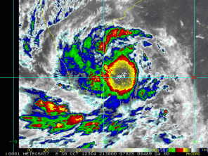
The most intense storm of Cyclone Nilam yet to reach Chennai. When it
reaches Chennai will float in Water. Please see Enhanced Infrared (IR)
Imagery below
Under the influence of this system, rainfall at most places with
scattered heavy to very heavy falls and isolated extremely heavy falls
(25o mm or more) during next 24 hrs. Rainfall at most places with
isolated heavy to very heavy falls would also occur over south coastal
Andhra Pradesh, Rayalaseema and north Interior Tamil Nadu during next 48
hrs.
Storm Surge:
Storm surge of about 1 -1.5 metre over the astronomical tide is
likely to inundate the low lying areas of Chennai, Kanchipuram &
Tiruvallur of Tamilnadu and Nellore district of Andhra Pradesh.
Winds:
Squally winds speed reaching 90 kmph gusting to 100 kmph would
prevail along and off north Tamil Nadu Chennai, Kanchipuram &
Tiruvallur of Tamilnadu, Puducherry and Nellore district of Andhra
Pradesh as the system comes closer to coast, becoming 80-90 kmph at the
time of landfall. Sea condition will be very rough to high along and off
north Tamil Nadu, Puducherry and adjoining south Andhra Pradesh coasts
during next 36 hours.


