Tuesday, August 24, 2010

Leh got 240mm in 24 hrs on the fateful day - GSI

On the night of 5th and 6th August 2010, between 00:00 hrs and 00:30 hrs, intensive rainfall followed by massive cloudburst in high altitude terrain of Leh (3505m), triggered numerous debris flows, mud flows (earth spreads) and sand flows. These widespread, composite flows in the over saturated slope forming materials caused 182 deaths including that of 3 foreign tourists, damaged 607 houses, breached all major communication networks to Leh town besides inflicting an unaccountable loss of livestock and agriculture fields. The disaster caused severe damage to the settlements in parts of Leh town, Sabu village, Choklamsar, Leh airport area, Nimu, Ney and Bazgo area around the town.

The Deputy Director General, Geological Survey of India, Northern Region, Lucknow nominated S/Sh. VK.Sharma, Sr. Geologist, Ajay Kumar and Pankaj Kumar Geologists to investigate the affected area. The GSI team visited the area from 11th August to 16th August, 2010. Trans Himalayan region, known for its cold and desert type climate owing to scanty rainfall and high sun radiations, had never witnessed such a disastrous scenario since the recorded historical times, notwithstanding the fact that cloudbursts occur frequently in the higher reaches of the mountains.

The Leh region represents a broad U shaped glacial valley of Indus river sandwiched between the lofty high ranges of Ladakh in the north and Zanskar in the south. Huge piedmont fans, river terraces, recent flood plains with prominent point bars, lateral bars and Aeolian deposits are the major geomorphic units of the terrain. Lacustrine deposits, indicating neotectonic activity, at places, have been observed near Sputik, Phyang and Nimu localities. Geologically, the affected region is occupied by Ladakh Granitoids and Quaternary sediments of glacial, fluvio-glacial, lacustrine, alluvial and Aeolian origins.

Widespread occurrence of varied, unconsolidated Quaternary drift deposits perched over gentle to fairly steep slopes are susceptible to mass movement under conditions of heavy saturation. Unprecedented rainfall of the order of 240 mm within 24 hours on account of cloud bursts in the Leh region during 4-6 August 2010 caused excessive mass movement of drift deposits and over spilling of the banks of the streams. Huge quantities of debris charged water moved in high energy regime destroying everything in its run out path.

In Leh area, the damage was confined in the catchments of Shaksaling nala, flowing from an elevation 3800 m to 3410 m. The debris flow mobilized and damaged the settlements, Bus Stand building, BSNL buildings, Hospital Complex, Radio Station, etc. in its 3 km run-out distance.The Sabu nala section, located about 11 km east of Leh, was affected the most by the cloudburst. The prolonged and heavy rainfall that reportedly lasted for 30 minutes raised the water level by about 10-15 feet and triggered the movement in slope debris. Water charged with debris, wooden logs and huge blocks of granite choked the course of the nala at bridge points near villages Zong, Myek and Ayu Sabu. The village settlements, forest and agricultural fields were damaged on account of over spilling of water mixed with debris and boulders, which flowed out with an appalling velocity, resulting death of 11 persons in Sabu village. When the debris blockades at bridge points breached due to further on-gush, the debris flow spread out in the downstream commands. This phase, lasting for about 30-45 minutes, was, in fact, the major cause of devastation to Choklamsar village, ITBP Camp, Leh-Manali route, New Choklamsar market, etc. It is reported that bodies of 48 people were recovered from the debris from these areas. A pile of debris upto 4 m high was observed at Leh–Manali road near New Choklamsar village. The debris further moved and spread along the road before falling into Indus river. Typical accumulation lobes of finer fraction of debris material were observed at tail end of the flow. The total run out distance of the debris flow from the epicenter of the cloudburst in the Sabu nala to the tip of the debris flow was of the order of 10 km. The maximum lateral spread of debris flow has been observed to be about 2 km. The morphological dimension of the debris flow and lateral spread belies the current figures of deaths and damages in the area. Stokma nala, flowing adjacent to Stokma village, was blocked by huge boulders and wooden logs resulting in diversion of the nala course towards the right bank in a geomorphic depression /dry nala. The Druk Padma Karpo Institute, generally referred to as “Ranchoo’s School”, located within the flow direction of mud/soil/silt has been affected. The surge of mudflow entered the classrooms of the School.

The airfield of the Leh, one of the highest airports in the world, is uniquely situated in a ‘U’ shaped wide valley. The granite hills around the airport area are covered by a pile of piedmont fans, lacustrine deposits and top layer of Aeolian sand. The field area is on the fluvio-glacial deposits. The cloudbursts affected the airfield when sand /Aeolian deposits and a section of terrace spread out over the air strip, thereby hampering the air traffic, and to an extent, the rescue operations.

The natural depressions on both sides of nala and low lying dry streams, where sprawl of settlements have grown, were in general, the worst affected sites of devastation; the higherelevation of slopes were the least affected locations. The mass movement in geologically fragile Quaternary sediments under unprecedented saturated conditions was largely responsible for the devastation. The selection of sites for rehabilitation in the area should, therefore, consider the local geomorphic setting, the nature of slope forming material and potential run-out zones of mass movements.

Sunday, August 22, 2010

Its NE-monsoon week for Tamilnadu - Widespread rainfall in the state

Coimbatore
------------
After a long disappointment over the delayed or inadequate rainfall during the South-West monsoon, a downpour lashed Coimbatore city and suburbs on Friday night.

Rainfall in mm during the last 24 hours till 8.30 a.m. on Saturday: Annur - 6, Peelamedu - 46.3, Mettupalayam - 50.2, Pollachi - 32, Periyanaickenpalayam - 40, Tamil Nadu Agricultural University - 48, Sulur - 37, Coimbatore South Taluk - 56, Thondamuthur - 30, Valparai Taluk - 8, Chincona - 4 and Chinnakallar - 3. Parambiulam - 4, Aliyar - 15.4, Thirumurthy - 5, Amaravathy - 27, Upper Nirar - 3, Lower Nirar - 1, Manacadavu - 46, Sircarapthy - 4, Upper Aliyar - 2, Kadamparai - 2, Uppar - 28, Valparai - 11, Thoonakadavu - 2, Vettaikaranpudur - 22, Pongalur - 28, Pollachi - 32 and Nallaru - 10.

Rain proved to be minimal in the Western Ghats along the catchments of the Parambikulam – Aliyar Project (PAP) reservoirs. Officials said that the rainfall during the South-West monsoon remained inadequate and the reservoirs are yet to reach the brim. The water level in dams on Saturday: Sholayar - 124.49 ft as against the Full Reservoir Level of 160, Parambikulam 47.85 ft as against the FRL of 72, Aliyar 115.80 ft as against the FRL of 120 ft, Thirumurthy reservoir 53.18 ft as against the FRL of 60 ft and Amaravathy had 62.50 ft as against the FRL of 90 ft.

Siruvani, the reservoir that takes care of the drinking water needs, witnessed a downpour. The rainfall in the catchment was 75 mm and at the foothills was 40 mm. The storage is said to be improving considerably. The storage stood at 28.37 feet as against the FRL of nearly 50 feet.

Thanjavur
-----------
Heavy rain lashed Thanjavur and Tiruvarur districts on Saturday. The agriculture department officials said the rain was beneficial for standing Kuruvai crop. According to P.Loganathan, Joint Director of Agriculture, Thanjavur , Kuruvai crop is in the tillering to flowering stage.

The rainfalls recorded in the 24-hour period ending at 8 a.m. Saturday were as follows (in mm): Thanjavur 15.3, Kumbakonam 25.4, Valangaiman 13.5, Ayyampettai 18, Papanasam 61, Thiruthuraipoondi 45.5, Neyvasal Thenpathi 66, Mannargudi 34, Muthupettai 66, Peravurani 14, Vettikadu 19, Orathanadu 41.5, Madukkur 44 and Pattukottai 31.

Nagapattinam
-------------
Torrential rain continued unabated for the second day with the district recording an average rainfall of 21.98 mm on Saturday. Vedaranyam recorded the highest rainfall of 70.40 mm. According to sources at Vedaranyam, the rains brought respite to the herbivores at Kodiakarrai sanctuary. However, flooded salt pans would slacken salt production, sources said. The morning's heavy rains in Nagapattinam block also brought in its first of rain-induced loss with inundation of a fair price shop here.

Rainfall recorded for the 24-hour period upto Saturday 8 a.m. are as follows (in mm): Vedaranyam 70.40 ; Tirupoondi 46; Thalainayar 26; Manalmedu 22; Nagapattinam 15.40; Mayiladuthurai 9 ; Sirkazhi 6; Tharangabadi 3; and Kollidam recorded nil rainfall.

Tiruchi
----------
Several parts of the Tiruchi district received intermittent shower on Saturday, bringing down the temperature. The sky remained overcast throughout the day.

Navalur Kuttapattu recorded the maximum of 43 mm of rainfall in the district.The following were the chief amount of rainfall recorded in other parts of the district during the 24-hour period ending at 8 a.m. on Saturday (in mm): Thuraiyur 36; Kovilpatti 27.40; Samayapuram 25; Ponnaniyar Dam 22; Marungapuri 20.20; Manapparai 17.20; Kuppampatti 15 and Vathalai Anicut 6.60. The district recorded an average of 11.35 mm of rainfall during the period.

Dharmapuri
---------------
Rain lashed Dharmapuri district from Friday night. Karimangalam experienced a maximum rainfall of 245 mm.Dharmapuri district experienced a maximum rainfall of 365 mm. All the lakes and ponds in and around Karimangalam were filled to the brim.

Krishnagiri
—————
In Krishnagiri district, many places received mo

Depression/Cyclone is possible near TN / Andhra coast

GFS Model
==============


NOGAPS Model
==============


IMD MM5 Model
==============


IMD GFS Model
==============


Canadian CMC GEM Model
=====================


NUWE Model
===========


Taiwan Model
===========

Nuwe predicts 250mm in next 4days for chennai


GFS predicts around 150mm


Foreca is little conservative and predicts around 80mm

All India Rainfall toppers from 1st January 2010 - 21st August 2010

  1. Cherrapunji (Meghalaya) - 1140 cm (Annual around 1100)
  2. Agumbe (Karnataka) - 488 cm (Annual over 750)
  3. Gaganbawada (Maharashtra) - 432 cm (Annual over 600)
  4. Shirali (Karnataka) - 351 cm (Annual over 400)
  5. Coochbehar (West Bengal) - 342 cm (Annual around 350)
  6. Passighat (Arunachal Pradesh) - 331 cm (Annual around 450)
  7. Mahabaleshwar (Maharashtra) - 321 cm (Annual over 600)
  8. Silchar (Assam) - 308 cm (Annual around 350)
  9. Honavar (Karnataka) - 307 (Annual over 350)
  10. Ratnagiri (Maharashtra) - 307 cm (Annual around 300)
  11. Buxa (West Bengal) - 302 cm (Annual around 550)
  12. Piravom (Kerala) - 302 cm (Annual around ??)
  13. North Lakhimpur (Assam) - 298 cm (Annual around 350)
  14. Panambur (Karnataka) - 293 cm (Annual over 350)
  15. Mangalore AP (Karnataka) - 292 cm (Annual around 400)
  16. Bhagamandala (Karnataka) - 291 cm (Annual over 600)
  17. Vadakara (Kerala) - 287 cm (Annual around ??)
  18. Karwar (Karnataka) - 282 cm (Annual around 400)
  19. Gangtok (Sikkim) - 280 cm (Annual over 350)
  20. Panjim (Goa) - 273 cm (Annual around 300)
  21. Jalpaiguri (West Bengal) - 268 cm (Annual around 350)
  22. Kottigehara (Karnataka) - 263 cm (Annual around ??)
  23. Harnai (Maharashtra) - 263 cm (Annual around 250)
  24. Mumbai Colaba (Maharashtra) - 263 cm (Annual around 200)
  25. Mumbai Santa Cruz (Maharashtra) - 262 cm (Annual around 250)
  26. Peermade (Kerala) - 256 cm (Annual around 500)
  27. Chinnakallar (Tamilnadu) - 253 cm (Annual around 500)
  28. Kannur (Kerala) - 248cm ( Annual around ??)
  29. Itanagar (Arunachal Pradesh) - 245 cm (Annual around 350)
  30. Matheran (Maharashtra) - 232 cm (Annual around 550)
  31. Kozhikode (Kerala) - 232cm ( Annual around ??)
  32. Kochi AP (Kerala) - 229cm ( Annual around ??)
  33. Dibrugarh (Assam) - 228 cm (Annual around 300)
  34. Valparai (Tamilnadu) - 222 cm (Annual around 350)
  35. Dahanu (Goa) - 215 cm (Annual around 250)
  36. Kottayam (Kerala) - 206cm ( Annual around ??)
  37. Devala (Tamilnadu) - 202 cm (Annual over 400)
Many stations in Kerala, Karnataka, Maharastra, and North East would have crossed 200-250 cm. Its very time consuming in calculating the rankings from the archived data.

Saturday, August 21, 2010

Southwest Monsoon Rainfall till 18th August 2010

This year desert region of Rajasthan & Gujarat have got plenty of rains, even a cyclone in the form of "PHET". The same can be said of south east coast of India (Tamilnadu & Andhra) got above normal rains, it has also witnessed a cyclone in the form of "LAILA". The trend will will continue in August and September.

The two regions which witnessed cyclones are getting heavy rains....does the cyclones had any role to play in this.....!


Top 5 (above normal rainfall)
------------------------------

1.Saurashtra & Kutch - 92%
2.West Rajasthan - 72%
3.Rayalaseema - 55%
4.Coastal AP - 45%
5.Tamil Nadu - 39%

Top 5 (below normal rainfall)
------------------------------

1.Jharkhand - 49%
2.Eastern U.P - 43%
3.West Bengal - 32%
4.Assam & Meghayala - 29%
5.Bihar - 28%

Monday, August 16, 2010

More on Leh Rainfall and cloudburst

13th August, 2010 - Times of India

The cloudburst has again brought out the glaring lack of adequate documentation on such sporadic weather events. J Srinivasan, chairman of Divecha Centre for Climate Change and head of Centre for Atmospheric and Oceanic Sciences, Indian Institute of Science, tells TOI's Jayashree Nandi about the need for extensive research on extreme weather events like the cloudburst. Excerpts:


What do you think of the cloudburst disaster at Leh?
Cloudbursts are events in which high rainfall occur over a very small area, in a very short time span (typically more than 100 mm/hour for a few hours). We do not have much data about this phenomenon. However, such events have occurred earlier in Uttarakhand and Himachal Pradesh. For instance, many people were killed in a cloudburst at Pithoragarh (Uttarakhand) on August 7, 2009. These events are rare in Jammu and Kashmir and hence the Leh cloudburst was unexpected. Extreme rainfall events (rainfall more than 100 mm/day) have increased by 50% during the past 50 years. This year we had floods in Pakistan, Gujarat and now in Jammu and Kashmir.

How long did it rain in Leh and across how much area?
India Meteorological Department data says it rained between 1.30 am and 2 am in Leh on August 6. A weather station near Leh recorded only 12.8 mm of rainfall in 24 hours. These events are extremely localized in an area probably less than 30 square kilometres. In August, the normal rainfall in Leh is 15.4 mm and the highest recorded in this season was 51 mm. But this time, the rainfall was probably much higher than that.

Have such events taken place earlier? Is it similar to 2005 Mumbai floods?
Such events occur every year in mountainous regions. Many events are not reported because of insufficient data. For instance, if it happens in some remote areas of Himachal Pradesh and if there is no a weather station close by and there is no habitation in those areas, the event doesn't get reported. Leh cloudburst is comparable to Mumbai floods because it rained for over 12 hours in Mumbai.

Could this be due to climate change?
IMD observations show that events of extreme rainfall have increased by 50% during the past 50 years. And, most climate models predict that global warming will increase such events. We cannot claim that a specific extreme event is due to global warming although we know that the probability of such events will increase as the earth becomes warmer.

Have any new observations been made on climate science recently?
In March, this year a disputed island on the Bangladesh-India border called Talpatti disappeared completely. Such events will occur more often in the future. The impact of sea level rise will not be seen in one or two years because the changes are slow. Similarly in case of temperature rise, IPCC predicts that there will be three degrees rise in 100 years. So that means a .03 degrees rise every year. We will not notice these changes easily unless we look at the long-term trend.

Do you think our policies are robust enough to deal with climate change?
Global warming will have serious impact on our life within 30 to 40 years. We have to act immediately because the transition from the present fossil-fuel dependent economy to one based on renewable energy will take many decades. Sadly, the vision and leadership on global warming has been lacking.

Sunday, August 15, 2010

South West Monsoon Rainfall Toppers 2010 till 15th August

All IndiaTop Rainfalls, over a limit of 2000mm, from 1st June 2010 to 15th August 2010.
  1. Cherrapunji: 5787 mm (-435)
  2. Agumbe: 4409 mm (-1075)
  3. Gaganbawada: 3840 mm
  4. Shirali: 3272 mm (+262)
  5. Mahableshwar: 3003 mm (-1234)
  6. Honavar: 2826 mm (+225)
  7. Ratnagiri: 2823 mm (+698)
  8. Buxa: 2808 mm
  9. Mangalore AP: 2644 mm(-25)
  10. Panambur: 2638 mm (+91)
  11. Bhagamandala: 2508 mm
  12. Karwar: 2499 mm (+185)
  13. Panjim: 2493 (+382)
  14. Harnai: 2456 mm (+502)
  15. Mumbai Colaba: 2312 mm (+778)
  16. Chinnakallar: 2276 mm
  17. Kottigehara: 2262 mm
  18. Mumbai Santa Cruz: 2219 mm (+512)
  19. Kannur: 2176 mm
  20. Matheran: 2160 mm
  21. Dahanu: 2011 mm (+513)

Tuesday, August 10, 2010

Changing weather pattern signals more rain for Ahmedabad

August 10, 2010 - Daily News Analysis

Amdavadis looking for respite from torrential rains have some bad news — though not for tomorrow or the day after. Weather pattern is changing and the city could be lashed by more heavy rains this monsoon and in coming years as it has been noted in the last decade that heavy rainfall events are increasing in the city.

On August 8, 2010 - 237.4 mm rainfall was recorded in Ahmedabad. The all-time record for 24-hour rainfall in August for the city is 250 mm recorded on August 30 in 1976. In the last decade, Sunday's rainfall was next only to the heaviest 24-hour rainfall ever recorded at Ahmedabad observatory at 325.9 mm on July 14, 2000.

An overview of the past decade shows that the frequency of heavy rainfall in the city has increased from 39 in 1979-88 to 50 in 1999-2008. As the city limped back to normalcy on Monday, it was learnt that the torrential rainfall that lashed the city on Sunday was the highest 24-hour rainfall in the last 10 years. With this, the city has recorded 930.4 mm rainfall till Monday, which is 130 mm more than normal. This figure exceeds the average annual seasonal rainfall in the city. With the change in formation of rain mechanisms, a significant rise in the number of average rainy days in month of July has also been noted. "The total average rainy days during the month of July for Gujarat were 15," said Kamaljit Ray, director of India meteorological department, Gujarat. The average rainy days in the state in July for the last 50 years are 11.

Moreover, for the last three decades, due to climate change, the state gets more rains from Arabian Sea than the Bay of Bengal. With this, a gradual rise in heavy rainfall events and city's average rainfall has been observed by the state's weather office. The city has witnessed a series of heavy rainfalls this season. It received 85.8 mm rain within 24 hours on August 2, 2010 which was also a heavy rainfall event of this monsoon for the city as well as the third highest 24-hour rainfall event in August during the last decade.

Sunday, August 8, 2010

Leh Cloudburst: How much it had rained ??

Source - Wall Street Journal, Hindu Business Line, Wikipedia

Sudden overnight rains caused flash floods in the town of Leh, the administrative center of the mountainous northern Ladakh region that borders China and Pakistan, killing more than 100 people and leaving hundreds injured, AP reported Friday. Many news reports described the downpour as a “cloudburst,” which the Indian Meteorological Department described Friday evening as a “disastrous weather event” in which “rate of rainfall may be of the order of 100mm [millimeters] per hour.”

Reports are that Leh received 48.6 mm rain in 60 seconds. In a special bulletin, the IMD said on Saturday that the high-impact event was so localised that that a nearby meteorological observatory of Indian Air Force (IAF) reported only 12.8 mm of rainfall during the 24 hours ending 5.30 a.m. on Friday. There is no official rainfall figure for the “fatal hours” available since it did not have an observatory in the region.

Comparing the Leh event with the year 2005 drencher over Mumbai, the latter was with two thunderstorms that poured 94 cm of rain in a radius of about 10 km around Mumbai together lasting about 18 hours on July 26 that year. In contrast, Colaba at the southern tip of Mumbai city had only 7 cm of rain during the same period. This is the nature of thunderstorms whose size and scale are small compared to low pressure vortices.

Based on the comparison the true rainfall figure in the affected area in Leh may never be known.
Many buildings crumbled after sudden rains and flash floods in Ladakh.
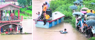
Rainfall is very, very scarce in the Ladakh region—it’s a dry, high-altitude region—so when it does happen it causes havoc because the houses and towns aren’t designed to deal with it. We were curious to find out exactly how much it had rained in millimeters, and whether this was typical for this time of year (it is monsoon season in India from June through September) and none of the day news stories carried the amount of rainfall.

A meteorologist at the Srinagar office of Indian Meteorological Department, G. R. Rathore, explained that the Srinagar office collected rainfall data for Leh from 1941 to 1981 (he put average annual rainfall for the period at just under 11 centimeters) and then stopped.

From 1981 on Mr. Rathore said that the IMD hasn’t had its own observatories in Ladakh and added that the Indian Air Force runs the three observatories there now. The armed forces have a strong presence in this region, which is part of India’s Kashmir state, because of its location bordering Pakistan and China. The IMD hopes to install one manned rain observatory in Leh by next summer and add several observatories across Ladakh as well, Mr. Rathore said.

According to him, the cloudburst lasted from 1:20 a.m. to 2:20 a.m. on Friday morning but he didn’t have data on how much rain had fallen in that hour because lines between Srinagar and Leh were down. He referred us to the weather section of the Indian Air Force in Srinagar for more information on the cloudburst. But at the Air Force, a senior official said that they weren’t supposed to disclose this information and referred us back to the civilian meteorological authorities. Getting this basic piece of data was starting to feel like a piece of classified information.The average for the whole month of august is 15.4 mm and the highest ever recorded in a 24-hour period is 51.3 mm, in August 1933.

Major Cloudburst Tragedies in India

  • August 31st, 1960 – 50mm of rain in 3hrs in Mandi and Suketi valley, Himachal Pradesh led to 103 deaths.
  • July, 1970 — Cloudburst in the upper catchment area led to a 15 metre rise in Alaknanda river. Entire river basin, from Hanumanchatti near Badrinath to Haridwar, affected; An entire village was swept away.
  • On August 15th 1997, 115 people were killed when a cloud burst came bustling and trail of death are all that is left behind in Chirgaon in Shimla district, Himachal Pradesh.
  • On August 17th, 1998 — A massive landslide following heavy rain and a cloudburst at Malpa village in Kali valley of Kumaon killed 250 people including 60 Kailash Mansarovar pilgrims. Among the dead was Odissi dancer Protima Bedi.
  • On July 16th 2003, About 40 persons were killed in flash floods caused by a cloudburst at Shilagarh in Gursa area of Kullu, Himachal Pradesh.
  • July 6th 2004, At least 17 people were killed and 28 injured when three vehicles were swept into Alaknanda river by heavy landslides triggered by a cloudburst that left nearly 5,000 pilgrims stranded near Badrinath shrine area in Uttaranchal's Chamoli district.
  • On August 16th 2007, 52 people were confirmed dead when a severe cloud burst occurred in in Bhavi village in Ghanvi, Himachal Pradesh.
  • On August 7th 2009, 38 people were killed in a landslide resulting from a cloudburst in Nachni area near Munshiyari in Pithoragatrh district of Uttarakhand.
  • On August 6th 2010, in Leh, a series of cloudbursts left 130 persons dead and over 600 injured in the frontier Leh town of Ladakh region in Jammu and Kashmir.

Record Cloudbursts

Duration Rainfall Location Date
1 minute 1.5 inches (38.10 mm) Barot, Himachal Pradesh, India 26 November, 1970
5 minutes 2.43 inches (61.72 mm) Port Bells, Panama 29 November, 1911
15 minutes 7.8 inches (198.12 mm) Plumb Point, Jamaica 12 May, 1916
20 minutes 8.1 inches (205.74 mm) Curtea-de-Arges, Romania 7 July, 1947
40 minutes 9.25 inches (234.95 mm) Guinea, Virginia, USA 24 August, 1906

Sunday, August 1, 2010

Southwest Monsoon Toppers from 1st June 2010 to 31st July 2010

1. Cherrapunji: 5499 mm (+255)
2. Agumbe: 3406 mm (-833)
3. Gaganbawada: 3370 mm
4. Shirali: 2935 mm (+316)
5. Buxa: 2728 mm
6. Honavar: 2628 mm (+466)
7. Ratnagiri: 2521 mm (+751)
8. Mahableshwar: 2515 mm (-700)
9. Panambur: 2452 mm (+296)
10. Mangalore AP: 2434 mm(+232)
11. Karwar: 2302 mm (+356)
12. Panjim: 2227 (+483)
13. Harnai: 2218 mm (+648)
14. Chinnakallar: 2156 mm
15. Bhagamandala: 2155 mm
16. Mumbai Colaba: 2046 mm (+775)
17. Kannur: 1977 mm
18. Kottigehara: 1972 mm
19. Mumbai Santa Cruz: 1963 mm (+571)
20. Peermade: 1880 mm
21. Jalpaiguri: 1825 (+348)
22. Kozhikode: 1762 (+16)
23. Valparai: 1674 mm
24. Coochbehar: 1655 mm (+120)
25. Dahanu: 1646 mm (+460)

Dehradun receives 364 mm, the second highest after 25 July 1966 when it got 467 mm.

July 31, 2010 - The Tribune

The Meteorological Department confirmed that the rainfall (364 mm) during the past 24 hours on 31st July 2010 was the second highest after 25 July 1966 when it rained 467 mm.

People being rescued in the Morowala area, near Dehradun, on Saturday.
People being rescued in the Morowala area, near Dehradun

Incessant downpour in the past 36 hours wrecked havoc in Dehradun city. Hundreds of houses got flooded as many boundary walls or constructions gave way to the pressure of gushing flood waters.

Residents cross a flooded stream at Nehru Gram and (right) submerged cars in a workshop in Dehradun on Saturday.
Residents cross a flooded stream at Nehru Gram and (right) submerged cars in a workshop in Dehradun.

The encroachers, who had extended their houses on drains or built these entirely on drains, paid for their erroneous acts with their houses getting flooded. The Irrigation Department, which is required to act in matters related to flooding of houses, had no clue to the extent of the damage. BK Tamta, Director Irrigation, said that he would assess the situation soon. Dr Vijayender Pal, counsellor, complained that despite the PWD and MDDA having their own Disaster Management Cell left it all on the Municipal Corporation to manage the crisis. Dehra Dun received 364 mm followed by Kashipur 245 mm over the past 24 hours. Excess rain has been recorded in Bageshwar, Chamoli, Champawat, Haridwar and Naini Tal since June 1 while other districts have received normal rainfall, Anand Sharma, Director, State Meteorological Centre here, said.

Saturday, July 31, 2010

Chennai - After May & June its July's turn to be cooler & wetter

Chennaiites are finding this month unusual — and they are not complaining. Not only has the monthly average temperature fallen , the days are getting good rains. The weatherman attributes this ‘monsoon flavour’ to low pressure formations and some other favourable meteorological systems. “The presence of an upper air cyclonic circulation over the west-central Bay with a southern tilt, a north-south trough over Chennai and a weak upper air system have the potential to bring scattered rainfall” said YEA Raj, deputy directorgeneral, Regional Meteorological Centre, Chennai.

The trough has been present for many days during this month, resulting in light showers. For the common man, it just means he has to take out the umbrella or get drenched, happily. “This evening was almost like a monsoon day with intermittent drizzle. This is a pleasant surprise in the city which sees an extended summer till as late as October. Many residents said the weather was similar to that experienced in winter due to murky sky and intermittent showers through the day. Evening showers in the past few days have left some of the low-level areas, particularly in suburbs, water-logged.

Chennai gets an average of 98 mm rain in July, this July Nungambakkam has registered 155 mm of rainfall. Unlike Coimbatore and Kanyakumari, which are in the windward side of the southwest monsoon, most areas do not benefit from good precipitation. Y. E. A. Raj, Deputy Director-General of Meteorology, Regional Meteorological Centre, said it was unusual for the city to be wet and receive such rainfall during July. Chennai normally receives more rainfall in August and September. While July 2008 and 2009 were comparatively drier, receiving 29 mm and 37 mm, the city has recorded good rains in July in the past.

Friday, July 30, 2010

Karnataka - Copious rainfall ensures steady flow into major reservoirs

Copious rainfall in the catchment areas of the Cauvery and the Kabini have ensured a steady inflow into the major reservoirs in the Cauvery command area since the last 24 hours. This has brought relief to the authorities, who were concerned about the slackening of the south-west monsoon as a result of which the water-level in the major dams—Krishnaraja Sagar (KRS), Kabini and Harangi

Krishnaraja Sagar dam (KRS)

Heavy rain in neighbouring district of Kodagu has augmented the inflow into the KRS. Officials in the Cauvery Command Area Development Authority (CADA) told The Hindu that the inflow into the reservoir was 14,874 cusecs on Thursday morning and it increased to nearly 17,000 cusecs by evening. The outflow from the reservoir was 3,500 cusecs. The water-level in the KRS was 91.30 ft as against the full reservoir level (FRL) of 124.80 ft. The live storage in the reservoir was 8.34 tmcft.

Kabini dam

The Kapila is rising owing to heavy rain in Wayanad district of Kerala which is the catchment area. As a result of incessant rain in the last 24 hours, the inflow into the Kabini dam at Beechanahalli in H.D. Kote increased significantly. The water-level in the reservoir is 2281.5 ft as against the FRL of 2,284 ft. The inflow into the reservoir was 22,271 cusecs at 6 a.m. but increased to 24.750 cusecs by evening.

Harangi reservoir

Harangi reservoir near Kushalnagar was let out into the river on Wednesday, as the water-level reached 2,854.70 ft as against the full reservoir level of 2,859 ft. The inflow increased to 16,646 cusecs. While 9,000 cusecs was released into the river on Wednesday night, this was reduced to 4,769 cusecs on Thursday morning.

The average rainfall for Kodagu district has crossed the 1,000-mm mark this year. According to statistics received on Thursday, the district recorded 1,132.33 mm of rainfall. The figure during the corresponding period last year was 1,754.65 mm. Bhagamandala received 98.40 mm of rainfall between 8 a.m. on Wednesday and 8 a.m. on Thursday. Shantalli in Somwarpet taluk continued to receive the highest rainfall of 156.20 mm during the same period, while Sampaje recorded 93.40 mm, Madikeri 92.40 mm, Srimangala 87 mm, Hudikeri 77.50 mm and Kodlipet 53.20 mm rainfall.

Tungabhadra dam

Water was released into the Tungabhadra Left Bank Canal (TLBC) on Wednesday to facilitate sowing of kharif crops in the command areas of Koppal and Raichur districts. Water will be supplied to the canal till mid-November.Water was also released into the Tungabhadra Right Bank High-Level Canal (RBHLC) and the Right Bank Low-Level Canal (RBLLC) to facilitate sowing of kharif crops in the command areas of Bellary district and parts of Andhra Pradesh. Water will be supplied to the canal till November-end.

This year, the release of water has begun even before the storage at the reservoir has not yet reached to its Full Reservoir Level (1,633 ft.). On Wednesday, July 28, the inflow was at 56.242 cusecs, the water level was 1,613.73 ft. with storage of 43.305 tmcft. of water.During the corresponding period last year, the level of the reservoir touched the Full Reservoir Level with storage of 104.340 tmcft.

Almatti dam

The water levels of various reservoirs built on River Krishna are slowly rising with more rains reported in the catchment area. Almatti dam in Karnataka is almost up to brim and is releasing more than one lakh cusecs of water to downstream Narayanpur dam in the same state. Narayanpur also started releasing water into Jurala in AP as the discharge from Almatti stepped up on Thursday. At Jurala, water level reached 1,043 feet against 1,045-feet full reservoir level. Irrigation officials opened 24 gates at Jurala to let 25,000 cusecs water downstream.

Srisailam reservoir

Increased inflows from Krishna and Tungabadhra saw a sudden surge of water into Srisailam reservoir where the water level touched 835 feet against 885-feet full reservoir level (FRL). This will help the authorities generate more power to ease the ongoing shortage.

Sriram Sagar reservoir

In the Godavari basin, the Sriram Sagar reservoir continues to receive copious inflows from upstream. The water level reached 1,075 feet against 1,091-feet full reservoir level. Singur, Nizamsagar, Yeluru reservoirs also received substantial inflows in the last three days with widespread rains in the catchment area.

Tuesday, July 27, 2010

Jamnagar gets 466 mm & Mandvi 449 mm as Rain batters Gujarat

A record-breaking 466 mm of rainfall was recorded in Jamnagar city in the past 24 hours. Rains continued to lash the city and district all through Monday night and early on Tuesday morning, causing major parts of the city to be inundated. According to reports from Jamnagar district control room, the city recorded the maximum rainfall with 466 mm up till Tuesday morning. This apart, Khambhaliya recorded 208 mm rainfall, Jodiya 212 mm, Lalpur 164 mm, Kalyanpur, 155 mm and Bhanvad 85 mm rainfall. Mandvi, too, got its highest 24-hour rainfall of 449 mm.

Caught in an endless spiral of incessant rainfall, many localities of Jamnagar in Gujarat remained submerged after waters from the city's Lakota lake overflowed in the wake of heavy rains earlier in the day. Local residents were left struggling for survival after water flooded their homes and inundated roads while bringing normal life in the city to a virtual standstill.

Hundreds of people and vehicles remained stranded due to roads either being cut-off by the floodwaters or closed as a precautionary measure."The Lakota pond, which is located in the heart of Jamnagar, has overflowed because of the rains. We have diverted the overflowing waters to the regional river, due to which the inflow has been significantly reduced. The outflow of water is also being controlled by regulating the gateways," said P. Swarup, Commissioner of Jamnagar.

Thursday, July 22, 2010

In 12 hours, Kodinar gets 355.6mm rainfall

22 July 2010 - Times of India

Heavy to very heavy rains have been reported from all across Saurashtra, with Kodinar and Talala receiving maximum rainfall in the past 24 hours till Wednesday evening. While more heavy showers have been predicted in the next 72 hours.
According to the state meteorological department, Kodinar witnessed a cloud burst type of situation in which 355.6 mm of rainfall was reported. Similarly, Talala also experienced heavy rains at 254 mm of rainfall by Wednesday evening, bureau reports said.

"Flash floods were reported in Kodinar and Talala, where people living in low-lying areas were evacuated to safer places on a war-footing. Total rainfall of the season in Kodinar has now gone up to 680 mm. Areas like Viratnagar, government quarters and Ravi Complex in Kodinar were deluged with most of the shops remaining shut and people indoors. In Talala, Hiran river experienced a flash flood which swamped Tirupati Nagar area. A house in Tirupati Nagar was struck by lightning. However, no casualty was reported," said a district administrative official from Junagadh. However, no untoward report was received from any place in Junagadh.

Other talukas to receive major rainfall were Una, Visavadar and Sutrapada apart from Junagadh city. Schools and colleges in both Kodinar and Talala remained closed due to heavy rains. Following flash flood in Hiran river in Talala, water was flowing seven feet high on the bridge linking Sangodragir area, turning it into a virtual island disconnected from administrative help. Reports said, in Kodinar, two gates of Shingoda dam were opened after it started overflowing, while in Talala, 15 feet of water intake was reported in Kamleshwer dam.

Sunday, July 11, 2010

Widespread Rainfall across Tamilnadu in last 2 days

July 10, 2010 - The Hindu

Ramanathapuram

Several parts of Ramanathapuram districts received heavy rain on Friday, bringing cheer to the people. The rain, which began at around 10.30 a.m., continued till around 12 noon. The town received good rainfall for the first time since May. Rainwater logged the streets such as Vandikkara Street, Vevekanandar Street, Salai Street, Kenikarai, Agraharam Road and other low lying areas of the town. The sky was overcast all through the day in Ramanathapuram. Other areas including Paramakudi, a few places around Thiruvadanai received moderate to heavy rain. The rain had brought down the temperature to a great extent, which was abnormally high during the last few days. It was expected that the present climate would continue to prevail for a few more days.

Sivaganga

Many parts of Sivaganga districts including Karaikudi and Sivaganga also received heavy downpour on Friday. The people of Karaikudi enjoyed the heavy rain that lashed at the early hours. Many streets were flooded due to the heavy rainfall.

Salem

Rains for nearly two hours lashed Salem city and its suburbs on Thursday night inundating all low-lying areas. An unidentified body was found in a drainage channel on Friday morning at Seelanaickenpatti here. Rain water mixed with sewage entered the houses at many low-lying areas in the city forcing the residents to undergo a sleepless night on Thursday. As Corporation was undertaking desilting works in the channel at Narayanana Nagar, the entire water overflowed on to the streets causing great hardship to the residents who insisted that the works should be completed before the onset of rainy season. Sankagiri registered the maximum rainfall of 66 mm followed by Salem city - 55.5 mm, Yercaud - 55, Mettur - 54.8, Edapadi - 44 and Omalur - 19.8.

Krishnagiri

Heavy rain lashed many parts of the Krishangiri districts on Thursday night. Due to this, water level in many water bodies in the districts have improved moderately. Flood water entered residential colonies in low-lying areas near KRP Dam in Krishnagiri. Villagers of Chinnamuthur, Sundekuppam and Periyamuthur said that even a brief spell of rain, flood water logged in the area for two-three days. This is because of the absence of proper storm water drain facilities and encroachments on the canals, villagers said. The water level of the KRP Dam on Thursday was 48 ft against its full height of 52 ft. Depression brought rain in the district whole night on Thursday, from 8 p.m. to 4 a.m. Water levels rose in many water bodies in Denkanikottai, Thali area. The maximum rainfall registered in Thali is 107 mm. Rainfall in other areas in mm: Nedungal - 96.4, Shoolagiri - 86.4, Denkankottai - 86, KRP Dam - 75, Krishnagiri - 37.5, Anchetti - 25, Uthangarai - 33, Hosur - 14.4 and Royakottai - 14.

Dharmapuri

Due to heavy downpour in Dharmapuri, many roads such as Four Roads junction, Tirupattur Road, Mohamed Ali Road and Pennagaram Road were flooded. In many places, rain water was flowing on the road along with sewage. Rainfall registered in mm: Palacode - 114, Dharmapuri - 105, Marandaalli - 92.6, Thumbal Alli Dam - 57, Pennagaram - 44, Pambar - 40, Nagavathi - 33 and Chinnar Dam - 27.

Erode

Erode district witnessed moderate to heavy showers on Thursday night. Bhavani Sagar registered a maximum rainfall of 64 mm followed by Perundurai (30 mm). A few other parts in the district including Erode town, Bhavani, Gobichettipalayam and Sathyamangalam also received moderate showers on Thursday night.

Saturday, July 10, 2010

Rainfall characteristics of Coimbatore district in Tamilnadu

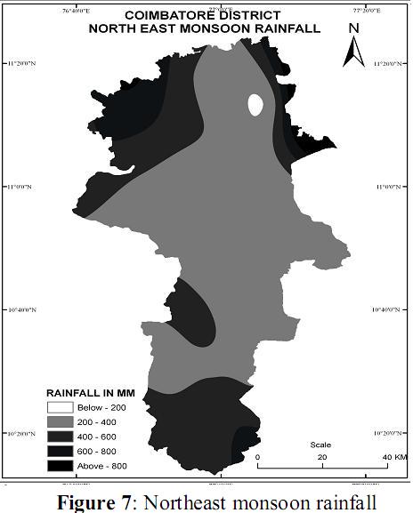
The Coimbatore district is situated in North Western part of the TamilNadu, the district covering an area of 4889 sq.km falls between 10°13'4" North to 11° 24'5" North latitude and 76° 39' 25" East to 77° 18' 26" East longitude. The temperature ranges between 18.32°C in the month of January and 36.42°C in the month of April. The area is bonded by Western Gates on West, Nilgiri hills in North West and Anaimalai and Palani hill in south. The district gradient of slope gradually decreases towards west to east, the district drain Bhavani, Noyal, Pallar, Amaravathi rivers. The study deals the rainfall characteristics of the Coimbatore District, which includes the spatial distribution and variability through different seasons, precipitation ratio and frequency occurrences. The study is based on 49 years of the monthly rainfall data for 33 rain gauge stations.

Winter Season

During the winter season the region heavily experiences low rainfall and it is driest among the all season which is maximum recorded at adjacent area of the region which Coonoor 86.82 mm in the month of February and lowest recorded at Coimbatore town which is 4.1mm in the month of February. The amount of rainfall decreases north west to north east and central part of region such as Annur, Sulur, Sultanpet, Krishnapurm and Podanur. Its rainfall average 20mm, this season contributes 2.07% to mean annual rainfall.

The variability rainfall is higher in this season while comparatively to other season, because low rainfall areas experiences greater fluctuation of variability. The lowest variability recorded adjacent area of region which is Coonoor 77.29% maximum at Palladam 232.2% and lowest variability recorded north western part which is Anaiktti 115.34% and southern part such as Upper Niradam (Chinnakallar), Solaiyar Nagar, Valaparai, Anaimalai experiences the low variability and central part eastern part gradually increase variability of rainfall, this fluctuations indicates the region experiences heavy low rainfall.

Summer Season

This is hot weather season the mount of rainfall gradually increases and however, the amount of rainfall occurrence in this season is largely due to convection effect, this season contributes 14.97% of mean annual rainfall this season average rainfall is 186.01mm and almost 80% area receives more than 186 mm accept north western and southern part of district. The highest amount of rainfall is recorded at the Upper Niradam (Chinnakallar) 224.14mm in the month of May and seasonal average is 370.7 mm and where the lowest rainfall is recorded in Krishnapuram 5.3mm and its seasonal average 69.8 mm.

The variability during this hot weather season maximum recorded at P.N. Palayam (86.36%), Attaikatti (79.93%), Negamam (78.34%), Sulur (77.86%), and Krishnapuram (76.07%) Coimbatore town (67.35%) Podanur (63.36%), Peelamedu (56.6%), and variability generally decreases from north to south and lowest variability experience adajecent area at Tthirumrthy Nagar 44.32%, and Solaiyar Nagar (49.07%), Sultanpet (52.03%), Vettaikarnpudur (54.93%), Mettupalayam (56.6%), and Pollchi (58.06%),.The variability of region highest experience in north and eastern part of region. This season will be low because west of influences by the pre monsoon winds.

South West Monsoon Season

Huge amount of rainfall variation noticed in this season, half of northern part of district receives low rain and half of southern part receives heaviest rainfall during season. The average rainfall of this season 573.20 mm and it is 46.13 % of mean annual rainfall. The highest seasonal rainfall recorded in Upper Niradam (Chinnakallar) (3655.5mm), and 1202.1 mm in the month of July, 996.25mm in June, 924.22 mm in August. Soliyar Nagar 2846.1mm, Anaimalais 2702.8mm, Valparai 2098.1mm, Topslip 772.4mm, lowest seasonal rainfall recorded in Krishnapurm 60.5mm, and 7.4 mm rainfall recorded in the month of August Sulur 113.9, Sultanpet 136.4 mm rainfall but southern parts of Districts receives more than 80% rainfall during this season. Most of south and west of Pollchi and Palaghat gap experiences highest rainfall, because of influence by leeward of Western Ghats. Upper Niradam, Soliyar Nagar, Anaimalais and Topslip are wettest places of district.

The south west monsoon rainfall variability experiences very less variability, comparatively to the other season, that is the 28.02% lowest at Topslip, Anaimalai, Valparai, Solaiyar Nagar and west of Pollachi and south of Chitrachavdi experiences very less variability due to heavy rainfall during this season. Where as very high variability experiences at adjacent area of region Poolankinar 89.99%, Sultanpet, Sulur, Krishnapurm, Podanur, and P.N.Palayam.

North East monsoon season

The North east monsoon season is important rainy season in the district, total rainfall in this season is low comparatively to the south west monsoon, but the eastern, north western, andcentral Upland region such as Annur, Sulur, Sultanpet, Negamam, Krishnapuram, Podanur Coimbatore town, and Peelamedu experiences maximum quantum of rainfall. This season contributes 36.82% of mean annual rainfall and average rainfall this season is 457.49 mm rainfall. The rainfall is gradually increase east to north west and south western part of the district, the highest rainfall recorded in adjacent area at Sundakapalayam 1713.3 mm, Upper Niradam 599.3, Anaikatty 589.64mm, Attakati 570.2, and where as lowest rainfall is recorded in Vettaikarnpdur 258.2mm, Annur 260.6mm and Krishnapuram 271.4mm, and Sultanpet 284.4mm, 80% of area receives well rain in this season, and most of agricultural activity takes places for showing crops.

The north east monsoon rainfall variability experiences higher than the south west monsoon due to lesser rain, the maximum variability recorded at adjacent area of such as Sundakaplayam 453.74% and lowest at Kethi 24.37% and north of Pollachi indicated higher variability and Anaimalai, Topslip, and Sultanpet experiences low rainfall variability. However rest of area experiences uniformity of variability.

Variability of Rainfall

“Variability defined as the deviation from mean” or “ratio of the standard deviation to the mean rainfall” and in other words variability of co-efficient of variation. Annual rainfall variability of region stretches between 19.69% to 387.91% at adjacent area of the region which is Coonoor and Sundakapalyam respectively, and 21.16% at Topslip and highest variability recorded in the central part of region that is Padanur (52.28%) and P.N.Palayam (51.81%) at northern part of region. Sultanpet experiences very low variability in eastern part district and in south western part Topslip and Vettaikarnpudur experiences low variability and Anaikatti, Coonoor experiences low variability in north western part of the region where as rest of district experiences homogenous variability in the region.

Coimbatore district bounded by Western Ghats,in the west and north of Nilagiri hills, in the south Anaimalai and Palani hills, and this district stretches in rain shadow region of Western Ghats. Normal rainfall of region during 1959­-2008 is 1242.49 mm and this district receives above normal rainfall of Tamil Nadu state. The maximum rainfall recorded at Upper Niradam (Chinnakallar) 1202.01mm in the month of July,and lowest of region recorded at Coimbatore town 4.1 mm in the month of February. The Coimabtore districts experiences driest in the month of January. The analysis of region heavy rainfall experiences towards the south and south western part and north western part in summer, south west monsoon and north east monsoon season, and huge amount of deficit in the east, north east and gradually in south east part and central part of district. The south west monsoon contributes the highest percentage of rainfall, which is 46.13% (573 mm), north east monsoon 36.82% (458 mm),summer 14.97% (186 mm) and winter season contribute lowest of which is 2.07 % (26 mm).

Source: Ishappa Muniyappa Rathod, Aruchamy.S, epartment of Geography, School of Geosciences,Bharathidasan University, Tiruchirappalli­.
Photo:-My Collections

Thursday, July 8, 2010

Ambala receives around 600 mm rainfall in three days

July 07, 2010 - The Hindu

Ambala, around 45 km from Chandigarh, has received around 600 mm rainfall in the last three days.

Ambala Rainfall
——————–
5th July – 174 mm
6th July – 191 mm
7th July – 197 mm

Major roads and rail tracks are flooded. Rivulets like Tangri near Ambala and Markanada were flowing above the danger mark. Few cracks have also appeared in the SYL canal in Kurukshetra where the water has crossed the danger mark and has entered many villages. "More enquiry counter to be opened at Ambala , the officer should show more maturity, " said Manish Tiwari , CPRO , Northern Railways.

Passengers in the Ambala Railway station are stranded as confusion still prevails as a result of the floods. "I have just arrived from Hissar, the train will start only by late evening. They may also cancel some trains, but what we expect is that at least they keep updating us about the trains services", said a stranded passenger. There was three to four feet of water at many places in Ambala, disrupting power supply and paralyzing normal life. Now the situation is under control,’ Ambala Deputy Commissioner S.P. Srow said.

Ambala, which is also a major army and air force base, remained under one to two feet of water. ‘No one from the administration is helping us. We don’t even have drinking water. All our household things have been damaged by water,’ said Savitri Devi, a resident of Ambala.

Friday, July 2, 2010

Rainfall characteristics of Nilgris in Tamilnadu

South West Monsoon

Greater part of the total annual rainfall (88 cm out of 170 cm) is brought by the south-west monsoon which blows from June to September and the heaviest falls occur in the stations of the which are furthest west and thus are the first to receive this monsoon. As it travels eastwards the current rapidly deposits the moisture with which it is laden and every succeeding station to the east gets less and less rain from it. Thus at Devala which is just at the top of the Western Ghats and receives the full force of the monsoon straight from the sea and the total annual rainfall is nearly 411 cm against the district average of 170 cm and of which rainfall during the south-west monsoon is 336 cm against the district average for that period of 88 cm. Gudalur is much sheltered from the south-west by the spurs on the northern boundary of the Ouchterlony Valley and there the annual rainfall drops to 229 cm of which nearly 177 cm are received during the south-west monsoon. But at Naduvattam which is above these spurs and on the very crest of the plateau and so just at the spot where the monsoon receives a sudden check in its progress the total rainfall rises again to nearly 258 cm of which 201 cm come with the south-west monsoon.

As the monsoon travels eastwards across the plateau it gives less and less rain. The fall during its course at Paikara (only four miles east of Naduvattam as the crow flies) drops to 131 cm, at Ooty (eight miles again east) to 57 cm and at Coonoor which is sheltered by the big spurs of the Dodabetta range to only 40 cm. This Dodabetta range checks the current and causes it to deposit the greater part of the moisture which it has left and all north east the recording stations to the east of it (Coonoor, Wellington, Kothagiri and Kodanad) receive less rain from it than they do from the north-east monsoon which blows in the directly opposite direction from October to December.

North East Monsoon

During the NE monsoon the above conditions are all reversed and the stations on the east of the district fare better than those on the west for the same reason as before namely that this monsoon reaches them first before it has deposited much of its moisture. At Coonoor which stands at the head of a ravine the mouth of which faces east and so collects the damp winds like a funnel the fall between October and December is as high as 78 cm. Wellington, which lies further within the plateau and is somewhat sheltered by the hills to the east of it receives only 54 cm. Kothagiri and Kodanad which are on the eastern crest of the plateau get 71 and 62 cm respectively and Kilkundah, where the rain driving up the Bhavani valley is checked receives 57 cm. But at Ooty which lies right under the protecting mass of Dodabetta, the fall during this monsoon is only 37 cm at Naduvattam, farther west only 32 cm and at Gudalur, down under the lee of the plateau only 27 cm.

Between January and March its the driest season of the year Coonoor, the other stations on the east of the district and Kilkundah all receive some benefit from the last showers of this north-east monsoon; but nowhere else is the fall in these three months as much as 5 cm. In April and May showers appear impartially all over the country and every station gets from 18-26 cm.

This unequal distribution of the rainfall, as is pointed out elsewhere in this book is of the greatest importance from an agricultural point of view plants and trees which will do well on the moisture west side refusing to flourish on the drier eastern slopes and also provides the resident in the district with a wide choice of climates. Its greatest extremes do not appear in the official statistics, for there are no recording stations in either the wettest or the driest parts of the district. Probably the annual rainfall on parts of the Kundahs is as much as 508 cm and that on the south eastern slopes above the Coimbatore district as little as 102 cm. The average annual fall in the district as a whole is raised by the heavy rain in its western stations and is thus larger than in any other collectorate except the two on the west Coast proper Malabar and South Canara.

In Ooty itself the total rainfall is only 123 cm which is less than that of Chennai 125 cm and very little more than the figures for the littoral districts (Chengelpet 115 cm, South Arcot 111 cm and Tanjore 114 cm) . Yet Ooty is popularly classed as a rainy spot. The chief reason for this is the fact that nearly two-fifths of its total fall is received during the three months (May — July) during which it is full of visitors and that this arrives in lighter showers than anywhere else in the district and is spread on an average of over 38 of the 92 days in those three months. A visitor who finds that more or less rain has fallen on 40 per cent of the days he has spent in the station and classes the place as damp locality.

Source: W. Francis, Asian Educational Services
Photo:-My Collections

Thursday, July 1, 2010

Chennai: One of the coolest June in decades

July 01, 2010 - Times Of India

If you enjoyed the weather more this June, you had good reason to feel as if spring was in the air. It was the third coolest June in 42 years with the mercury dipping below the average for 14 days in the month, said Met officials. “This June, the average fell from 37 to 35.2 degrees Celsius. In 1991, it was 34.3 degrees and 34.9 degrees in 1996,” said YEA Raj, deputy director general, regional meteorological centre. Since 2005, the monthly average has been higher. With the onset of the southwest monsoon, local thunder storm activity brought in a good amount of rainfall to the city. Met officials said the arrival of cyclone Laila and the rainfall in the wake of its withdrawal was the beginning of a good run on the weather front. The city enjoyed nine days of rainfall of varying degrees this June. Although nowhere near the record 698 mm seen in 1996, Nungambakkam registered 137 mm and Meenambakkam 130. The city’s normal is around 40 mm for June, added Raj. In 1991, the city received 264 mm in June.

The thunderstorm activity was not restricted to the city alone, with all but three districts receiving excess rainfall. Against the normal of 42.1 mm, the state received 78.5 mm, an 87% excess. “The last month has been exceedingly good for the state. The trend is likely to continue in July as well, and we can expect more rains and cooler days,” added Raj.

Sunday, June 20, 2010

Rainfall characteristics of Kerala

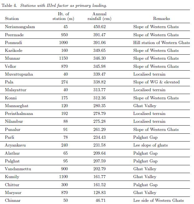
The south-west monsoon current, which brings in most of the annual rainfall to Kerala, gets a forced ascent at the Ghats and the windward slopes experience very heavy rainfall. However, rainfall is not uniformly distributed on the windward slopes and there are pockets of very heavy rainfall and relatively less rainfall. The coastal region of the state also receives abundant rainfall. The results suggest that Kerala can be divided into three unique rainfall regions, each region having a similar covariance structure of annual rainfall. Stations north of 10.N (north Kerala) fall into one group and they receive more rainfall than stations south of 10.N (south Kerala). Group I stations (table 2) receive more than 65% of the annual rainfall during the south-west monsoon period, whereas stations falling in Group II (table 3) receive 25-30% of annual rainfall during the pre-monsoon and the north-east monsoon periods. Group III stations (table 4) with IIIrd factor as the primary loading, i.e., IIIrd factor greater than Ist and IInd factor. The meteorology of Kerala is profoundly influenced by its orographical features, however it is difficult to make out a direct relationship between elevation and rainfall. Local features of the state as reflected in the rainfall distribution are also clearly brought out by the study. The classification of Kerala according to the important factors is given in figure 2.

Group I stations - 75% of the annual rainfall from South West Monsoon

There are 28 rainfall stations in Group I, which can be again classified into 2 according to the contribution of south-west monsoon rainfall (see regions Ia and Ib in figure 2): Stations receiving more than 75% of the annual rainfall during the south-west monsoon, and stations receiving 65-75% of the annual rainfall during the south-west monsoon season. All these stations are situated north of 10.N (north Kerala) and receive more rainfall than stations south of 10.N (south Kerala). This division into north and south Kerala arises from the fact that monsoon rainfall progresses from south to north along the west coast of India and there are differences in the rainfall characteristics between the southern and northern parts of the state. An examination of the monthly rainfall pattern shows that rainfall is highest in June south of 10.N while north Kerala experiences the highest rainfall in July. With each surge in the monsoon current,rainfall is more in north Kerala than in the south and the frequency of surges is higher in July than in June. The active spells of monsoon are also more in July and August. Further, under weak monsoon conditions there is divergence over south Kerala causing little or no rain, while there is convergence resulting in rain over north Kerala on many occasions.

Group II stations - 30% of annual rainfall during pre-monsoon and north east monsoon

South Kerala stations have the second factor as the primary factor and there are 26 stations in Group II. All these stations receive 25-30% of the annual rainfall during the pre-monsoon and north east monsoon season. (i) Precipitation during pre-monsoon is mainly from thundershowers and there is an increased thunderstorm activity in the southern tip of Kerala state from March onwards increasing progressively with the advance of the season. May makes the maximum contribution to the rainfall of the pre-monsoon period (March - May). The south-west monsoon advances over south Kerala between 11th and 31st May in nearly 50% of the years, and this is a contributory factor for the pronounced rainfall maximum over south Kerala during this season.

(ii) Most of the rainfall during north-east monsoon is closely associated with the westward passage of storms and depressions, which are remnants of low pressure systems that move into the Bay of Bengal. The tapering shape of the peninsula and the lower elevation of the Western Ghats in the south are the main reasons for rainfall during this season in south Kerala.

Group III stations - Orographic rainfall, Localized terrain & leeward slope of the Ghats

The meteorology of Kerala is profoundly influenced by its orography. This is reflected as the third factor in the factor analysis. Of the 77 stations, 23 stations have this factor as the primary loading. Even though these stations have the third factor as their primary loading, all these stations do not have the same rainfall pattern and can be classified into three groups. (i) There are 8 stations that receive very heavy annual rainfall (> than 336 cm) and are located on the windward slope of the Ghats. On the windward side of mountains, moist air is forced up the slope, where it cools and condenses, leading to precipitation. These peaks also provide convection points of instability. This instability will be triggered when the orographic lifting is strong enough to force air parcels to ascend to their level of free convection. Thus, the heavy rainfall over the windward slopes depends not only on the elevation of the station but also on the wind velocity perpendicular to the mountain range and on the moist static stability.

(ii) There is a second group of stations that receive normal annual rainfall and has the third factor as their primary loading factor. The local features of the stations are also significant in this factor. For example Punalur a station in south Kerala is surrounded by rocky terrain on its four sides and this station experiences very high thunderstorm activity.

(iii) Stations that lie on the leeward slope of the Ghats and stations situated in the Palghat Gap receive very less mean annual rainfall (less than 224 cm) and load primarily on the third factor. Air flowing across a mountain range will be forced upwards, and therefore it cools and produces local precipitation. When the air reaches the other side of the range, it's been effectively "wrung out" and tends to be dry. This produces a "rain shadow" effect on the lee side of mountains (the side away from the wind direction) where it tends to be dry.

The complex relationship between topography and precipitation in mountainous regions is evident in the pattern of rainfall distribution. A frequency table showing the rainfall and elevation is illustrated in table 5. Stations are classified according to their elevation into 5 groups. The normal rainfall of Kerala for the period of study is 280 cm and stations having rainfall greater than 20% of the state normal (i.e., greater than 336 cm) are classified as excess rainfall stations and those having rainfall less than 20% of the state normal (i.e., less than 224 cm) are grouped as scanty rainfall stations. It can be seen from table 5 that while there are 4 excess rainfall stations with elevation between 500m and 1000m 3 stations with the same altitude experiences only scanty rainfall. Figure 3 illustrates the rainfall versus the elevation of each station. It is evident from the figure that it is difficult to make out a direct relationship between elevation and rainfall. The spatial variability of mean annual precipitation depends upon the topographic factors like exposure of the station to the prevailing wind, elevation, orientation, and slope of the mountain.

Source: Anu Simon and K Mohankumar, Department of Atmospheric Sciences, Cochin University of Science and Technology, India

Photo:-My Collections

Rainfall data from 1-Jan-2010 to 19-Jun-2010

India toppers from 1.1.10 to 19.6.10
-----------------———————————–—————
Cherrapunji (Meghalaya) - 681 cm
Passighat (Arunachal Pradesh) - 207 cm
Silchar (Assam) - 204 cm
North Lakhimpur (Assam) - 165 cm
Gangtok (Sikkim) - 152 cm
Itanagar (Arunachal Pradesh) - 150 cm
Dhubri (Assam) - 148 cm
Dibrugarh (Assam) - 142 cm
Vadakara (Kerala) 134 cm
Piravom (Kerala) – 130 cm
Coochbehar (West engal) - 124 cm
Lengpui (Mizoram) - 115 cm
Guwahati (Assam) - 113 cm
Kottayam (Kerala) - 110 cm
Kochi (Kerala) - 108 cm
Agartala (Tripura) - 107 cm
Tezpur (Assam) - 106 cm
Jalpaiguri (West Bengal) - 105 cm
Subramanya (Karnataka) - 105 cm
Kozhikode (Kerala) - 103 cm


Tamil Nadu toppers from 1.1.10 to 19.6.10
-----------------——————————————————
Valparai (Coimbatore dt) – 87 cm
Chinna Kallar (Coimbatore dt) - 77 cm
Pechiparai (Kanyakumari dt) – 72 cm
Devala (Nilgiris dt) – 69 cm
Kuzhithurai (Kanyakumari dt) – 58 cm
Kodaikanal (Dindigul dt) – 45 cm
Thuckalay (Kanyakumari dt) – 43 cm
Thalli (Krishnagiri dt) – 43 cm
Boothapandi (Kanyakumari dt) – 38 cm
Gudalur Bazaar (Nilgiris dt) - 38 cm
Ketti (Nilgiris dt) – 36 cm